Loch Assynt + Loch Leitir Easich fishing map is included in Scotland - Highland Lochs nautical charts folio. It is available as part of iBoating : Inland Europe Marine & Fishing App (now supported on multiple platforms including Android, iPhone/iPad, MacBook, and Windows(tablet and phone)/PC based chartplotter. ).
With our Lake Maps App, you get all the great marine chart app features like fishing spots, along with Loch Assynt + Loch Leitir Easich lake depth map. The fishing maps app include HD lake depth contours, along with advanced features found in Fish Finder / Gps Chart Plotter systems, turning your device into a Depth Finder. The Loch Assynt + Loch Leitir Easich Navigation App provides advanced features of a Marine Chartplotter including adjusting water level offset and custom depth shading. Fishing spots and depth contours layers are available in most Lake maps. Lake navigation features include advanced instrumentation to gather wind speed direction, water temperature, water depth, and accurate GPS with AIS receivers(using NMEA over TCP/UDP). Autopilot support can be enabled during ‘Goto WayPoint’ and ‘Route Assistance’.
Have more questions about the Nautical Chart App? Ask us.
Fishing Info for Loch Assynt + Loch Leitir Easich
Loch Assynt (Scottish Gaelic: Loch Asaint) is a freshwater loch in Sutherland, Scotland, 8 kilometres (5.0 mi) east-north east of Lochinver. Situated in a spectacular setting between the heights of Canisp, Quinag and Beinn Uidhe, it receives the outflow from Lochs Awe, Maol a' Choire, and Leitir Easaich. It discharges into the sea at Loch Inver, via the river Inver. The general trend of the loch is west-northwest and east-southeast, while the western end bends sharply at Loch Assynt lodge to the southwest. The loch is 9.65 kilometres (6 mi) long, and about 1.5 kilometres (1 mi) in maximum breadth. The total area is approximately 800 hectares (1,980 acres) and its drainage basin is over 111 square kilometres (43 sq mi). The total volume of the loch is approximately 250 million cubic metres (9 billion cubic feet) and the maximum depth is 86 metres (282 feet). There is excellent fishing for trout, sea-trout, and salmon. Ardvreck Castle, once held by the MacLeods and Mackenzies, occupies a promontory on the north shore, west of Inchnadamph. The elevation of the loch's surface above sea level varies with the levels of rainfall but has been measured as 65.55 metres (215.1 ft). * The western end of Loch Assynt with Quinag in the distance * Loch Assynt from * Ardvreck Castle
More on Wikipedia...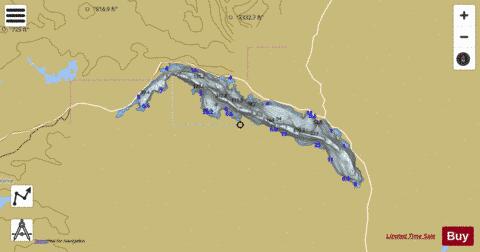
Loch Assynt + Loch Leitir Easich Fishing Map Stats | |
| Title | Loch Assynt + Loch Leitir Easich |
| Scale | 1:24000 |
| Area * | 1988.88 acres |
| Shoreline * | 22.50 miles |
| Min Longitude | -5.13 |
| Min Latitude | 58.15 |
| Max Longitude | -4.98 |
| Max Latitude | 58.19 |
| Edition Label 1 | |
| Edition Label 2 | |
| Edition Label 3 | |
| Id | II_SCOT_74422158_0_scot |
| Country | Inland Europe |
| Projection | Mercator |
| * some Stats may include nearby/connecting waterbodies | |
| |||||||||||||||||||||||||||||||||||||||||||||||||||||||||||||||||||||||||||||||||||||||||||||||||||||||
|