Loch Monar (Beauly Basin) fishing map is included in Scotland - Highland Lochs nautical charts folio. It is available as part of iBoating : Inland Europe Marine & Fishing App (now supported on multiple platforms including Android, iPhone/iPad, MacBook, and Windows(tablet and phone)/PC based chartplotter. ).
With our Lake Maps App, you get all the great marine chart app features like fishing spots, along with Loch Monar (Beauly Basin) lake depth map. The fishing maps app include HD lake depth contours, along with advanced features found in Fish Finder / Gps Chart Plotter systems, turning your device into a Depth Finder. The Loch Monar (Beauly Basin) Navigation App provides advanced features of a Marine Chartplotter including adjusting water level offset and custom depth shading. Fishing spots and depth contours layers are available in most Lake maps. Lake navigation features include advanced instrumentation to gather wind speed direction, water temperature, water depth, and accurate GPS with AIS receivers(using NMEA over TCP/UDP). Autopilot support can be enabled during ‘Goto WayPoint’ and ‘Route Assistance’.
Have more questions about the Nautical Chart App? Ask us.
Fishing Info for Loch Monar (Beauly Basin)
Loch Monar is a freshwater loch situated at the head of Glen Strathfarrar, in the West Highlands of Scotland. Since the 1960s, it has been dammed as part of the Affric-Beauly hydro-electric power scheme. The loch is fed by a number of small burns running off the surrounding hills. The loch's primary outflow is the Garbh-uisge, which joins with the Uisge Misgeach to form the River Farrar. Much of the area around Loch Monar is remote and mountainous. This include the Munros of , Sgùrr Choinnich, Maoile Lunndaidh, Lurg Mhòr and Bidein a' Choire Sheasgaich.
More on Wikipedia...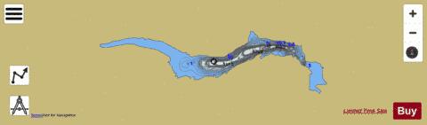
Loch Monar (Beauly Basin) Fishing Map Stats | |
| Title | Loch Monar (Beauly Basin) |
| Scale | 1:24000 |
| Area * | 2489.67 acres |
| Shoreline * | 26.64 miles |
| Min Longitude | -5.20 |
| Min Latitude | 57.40 |
| Max Longitude | -4.99 |
| Max Latitude | 57.43 |
| Edition Label 1 | |
| Edition Label 2 | |
| Edition Label 3 | |
| Id | II_SCOT_74422240_0_scot |
| Country | Inland Europe |
| Projection | Mercator |
| * some Stats may include nearby/connecting waterbodies | |
| ||||||||||||||||||||||||||||||||||||||||||||||||||||||||||||||||||||||||||||||||||||||||||||||||||||||||
|