Loch Treig (Lochy Basin) fishing map is included in Scotland - Highland Lochs nautical charts folio. It is available as part of iBoating : Inland Europe Marine & Fishing App (now supported on multiple platforms including Android, iPhone/iPad, MacBook, and Windows(tablet and phone)/PC based chartplotter. ).
With our Lake Maps App, you get all the great marine chart app features like fishing spots, along with Loch Treig (Lochy Basin) lake depth map. The fishing maps app include HD lake depth contours, along with advanced features found in Fish Finder / Gps Chart Plotter systems, turning your device into a Depth Finder. The Loch Treig (Lochy Basin) Navigation App provides advanced features of a Marine Chartplotter including adjusting water level offset and custom depth shading. Fishing spots and depth contours layers are available in most Lake maps. Lake navigation features include advanced instrumentation to gather wind speed direction, water temperature, water depth, and accurate GPS with AIS receivers(using NMEA over TCP/UDP). Autopilot support can be enabled during ‘Goto WayPoint’ and ‘Route Assistance’.
Have more questions about the Nautical Chart App? Ask us.
Fishing Info for Loch Treig (Lochy Basin)
Loch Treig (Scottish Gaelic: Loch Trèig, meaning loch of death) is a 9 km freshwater loch situated in a steep-sided glen 20 km east of Fort William, in Lochaber, Highland, Scotland. While there are no roads alongside the loch, the West Highland Line follows its eastern bank. Since 1929 Loch Treig has been a reservoir, retained behind the , forming part of the Lochaber hydro-electric scheme, which required diversion of the West Highland Railway. The increase in water level following the construction of the dam submerged the small communities of Kinlochtreig and Creaguaineach at the loch's southern end, which had historically hosted locally important markets and had been the end point of a cattle drovers' road.
More on Wikipedia...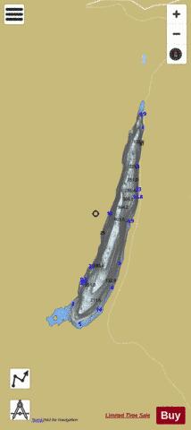
Loch Treig (Lochy Basin) Fishing Map Stats | |
| Title | Loch Treig (Lochy Basin) |
| Scale | 1:24000 |
| Area * | 1813.45 acres |
| Shoreline * | 13.70 miles |
| Min Longitude | -4.77 |
| Min Latitude | 56.78 |
| Max Longitude | -4.71 |
| Max Latitude | 56.86 |
| Edition Label 1 | |
| Edition Label 2 | |
| Edition Label 3 | |
| Id | II_SCOT_74422247_0_scot |
| Country | Inland Europe |
| Projection | Mercator |
| * some Stats may include nearby/connecting waterbodies | |
| ||||||||||||||||||||||||||||||||||||||||||||||||||||||||||||||||||||||||||||||||||||||||||||||||||||||||
|