Loch Shurrery fishing map is included in Scotland - Highland Lochs nautical charts folio. It is available as part of iBoating : Inland Europe Marine & Fishing App (now supported on multiple platforms including Android, iPhone/iPad, MacBook, and Windows(tablet and phone)/PC based chartplotter. ).
With our Lake Maps App, you get all the great marine chart app features like fishing spots, along with Loch Shurrery lake depth map. The fishing maps app include HD lake depth contours, along with advanced features found in Fish Finder / Gps Chart Plotter systems, turning your device into a Depth Finder. The Loch Shurrery Navigation App provides advanced features of a Marine Chartplotter including adjusting water level offset and custom depth shading. Fishing spots and depth contours layers are available in most Lake maps. Lake navigation features include advanced instrumentation to gather wind speed direction, water temperature, water depth, and accurate GPS with AIS receivers(using NMEA over TCP/UDP). Autopilot support can be enabled during ‘Goto WayPoint’ and ‘Route Assistance’.
Have more questions about the Nautical Chart App? Ask us.
Fishing Info for Loch Shurrery
Loch Shurrery (also known as Loch Shurrey) is a small, shallow, lowland freshwater loch lying approximately 8 mi (13 km) south west of Thurso in the Scottish Highlands. The loch has a somewhat elliptical shape with a perimeter of 7.4 km (4.6 mi). It is approximately 1.25 mi (2.01 km) long, has an average depth of 4.5 ft (1.4 m) and is 7 ft (2.1 m) at its deepest. The loch was surveyed on 6 October 1902 by John Parsons and T.R.H. Garrett and later charted as part of Sir John Murray's Bathymetrical Survey of Fresh-Water Lochs of Scotland 1897-1909. A dam lies to the north end of the loch. Approximately 200 yards (180 m) from the northern end of the loch are the archaeological remains of an Iron Age hut circle with a medium-sized oval house. Some pottery was found at the site. At the southern end of the loch is Lambsdale Leans, a cairn with possible cist or chamber. Two Viking graves lie nearby. The loch is used for fishing and the Dounreay Fly Fishing Association keeps a boat on the loch for members and visitors.
More on Wikipedia...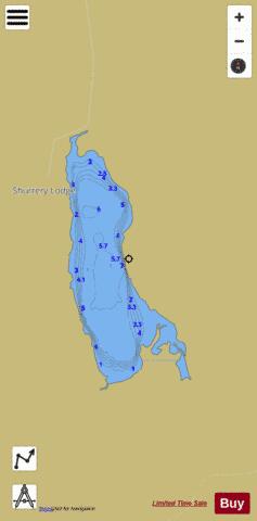
Loch Shurrery Fishing Map Stats | |
| Title | Loch Shurrery |
| Scale | 1:12000 |
| Area * | 259.27 acres |
| Shoreline * | 5.22 miles |
| Min Longitude | -3.65 |
| Min Latitude | 58.47 |
| Max Longitude | -3.63 |
| Max Latitude | 58.49 |
| Edition Label 1 | |
| Edition Label 2 | |
| Edition Label 3 | |
| Id | II_SCOT_74422297_1_scot |
| Country | Inland Europe |
| Projection | Mercator |
| * some Stats may include nearby/connecting waterbodies | |
| |||||||||||||||||||||||||||||||||||||||||||||||||||||||||||||||||||||||||||||||||||||||||||||||||||||||
|