Loch Thom (Clyde Basin) fishing map is included in Scotland - Inverclyde Lochs nautical charts folio. It is available as part of iBoating : Inland Europe Marine & Fishing App (now supported on multiple platforms including Android, iPhone/iPad, MacBook, and Windows(tablet and phone)/PC based chartplotter. ).
With our Lake Maps App, you get all the great marine chart app features like fishing spots, along with Loch Thom (Clyde Basin) lake depth map. The fishing maps app include HD lake depth contours, along with advanced features found in Fish Finder / Gps Chart Plotter systems, turning your device into a Depth Finder. The Loch Thom (Clyde Basin) Navigation App provides advanced features of a Marine Chartplotter including adjusting water level offset and custom depth shading. Fishing spots and depth contours layers are available in most Lake maps. Lake navigation features include advanced instrumentation to gather wind speed direction, water temperature, water depth, and accurate GPS with AIS receivers(using NMEA over TCP/UDP). Autopilot support can be enabled during ‘Goto WayPoint’ and ‘Route Assistance’.
Have more questions about the Nautical Chart App? Ask us.
Fishing Info for Loch Thom (Clyde Basin)
Loch Thom is a reservoir which since 1827 has provided a water supply to the town of Greenock in Inverclyde, Scotland. It is named after the civil engineer Robert Thom who designed the scheme which created the reservoir and delivered water via a long aqueduct known as The Cut. Today, as well as providing a water supply, the loch is used for sport fishing and forms part of the Clyde Muirshiel Regional Park with several attractive walks and a centre at Cornalees Bridge providing nature study facilities. The loch is about 2.4 km from north to south, curving to the east in a rough C-shape, and is at an elevation of about 195 m above sea level. From the northern arm an outlet feeds southwest a short distance to a compensation reservoir at the centre of the "C", which then connects at Cornalees Bridge to the start of The Cut.
More on Wikipedia...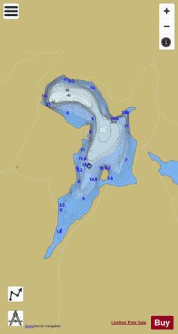
Loch Thom (Clyde Basin) Fishing Map Stats | |
| Title | Loch Thom (Clyde Basin) |
| Scale | 1:12000 |
| Area * | 363.03 acres |
| Shoreline * | 5.51 miles |
| Min Longitude | -4.80 |
| Min Latitude | 55.90 |
| Max Longitude | -4.78 |
| Max Latitude | 55.92 |
| Edition Label 1 | |
| Edition Label 2 | |
| Edition Label 3 | |
| Id | II_SCOT_74422367_1_scot |
| Country | Inland Europe |
| Projection | Mercator |
| * some Stats may include nearby/connecting waterbodies | |
| ||||||||||||||||||||||||||||||||||||||||||||||||||||||||||||||||||||||||||||||||||||||||||||||||||||||||
|