Losna fishing map is included in ֳ˜stfold nautical charts folio. It is available as part of iBoating : Norway Marine & Fishing App (now supported on multiple platforms including Android, iPhone/iPad, MacBook, and Windows(tablet and phone)/PC based chartplotter. ).
With our Lake Maps App, you get all the great marine chart app features like fishing spots, along with Losna lake depth map. The fishing maps app include HD lake depth contours, along with advanced features found in Fish Finder / Gps Chart Plotter systems, turning your device into a Depth Finder. The Losna Navigation App provides advanced features of a Marine Chartplotter including adjusting water level offset and custom depth shading. Fishing spots and depth contours layers are available in most Lake maps. Lake navigation features include advanced instrumentation to gather wind speed direction, water temperature, water depth, and accurate GPS with AIS receivers(using NMEA over TCP/UDP). Autopilot support can be enabled during ג€˜Goto WayPointג€™ and ג€˜Route Assistanceג€™.
Have more questions about the Nautical Chart App? Ask us.
Fishing Info for Losna
Losna is a lake which lies in the municipalities of Ringebu and ֳ˜yer in Innlandet county, Norway. Losna is a part of the Gudbrandsdalslֳ¥gen river, which is in this region so broad and runs so slowly that this stretch is recognized as a lake. The 9.84-square-kilometre (3.80 sq mi) lake has a length of 11 kilometres (6.8 mi) and it lies at an elevation of 181 metres (594 ft) above sea level and the maximum depth of the lake is 55 metres (180 ft) below the surface. The European route E6 highway and the Dovrebanen railway line both run along the shores of the lake.
More on Wikipedia...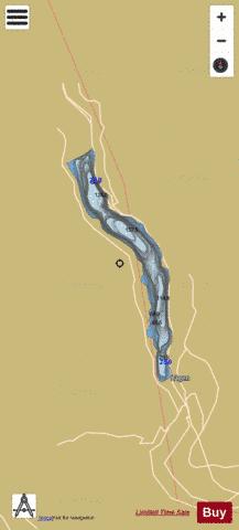
Losna Fishing Map Stats | |
| Title | Losna |
| Scale | 1:24000 |
| Min Longitude | 10.20 |
| Min Latitude | 61.32 |
| Max Longitude | 10.29 |
| Max Latitude | 61.41 |
| Edition Label 1 | |
| Edition Label 2 | |
| Edition Label 3 | |
| Id | NO_LK_144 |
| Country | Norway |
| Projection | Mercator |
| * some Stats may include nearby/connecting waterbodies | |
|