Lahontan Reservoir fishing map is available as part of iBoating : USA Marine & Fishing App(now supported on multiple platforms including Android, iPhone/iPad, MacBook, and Windows(tablet and phone)/PC based chartplotter.).
With our Lake Maps App, you get all the great marine chart app features like fishing spots, along with Lahontan Reservoir depth map. The fishing maps app include HD lake depth contours, along with advanced features found in Fish Finder / Gps Chart Plotter systems, turning your device into a Depth Finder. The Lahontan Reservoir Navigation App provides advanced features of a Marine Chartplotter including adjusting water level offset and custom depth shading. Fishing spots and depth contours layers are available in most Lake maps. Lake navigation features include advanced instrumentation to gather wind speed direction, water temperature, water depth, and accurate GPS with AIS receivers(using NMEA over TCP/UDP). Autopilot support can be enabled during ‘Goto WayPoint’ and ‘Route Assistance’.
Now i-Boating supports Fishing Points in Lahontan Reservoir.
Have more questions about the Nautical Chart App? Ask us.
Fishing Info for Lahontan Reservoir
Modern Lake Lahontan is a reservoir on the Carson River in northwest Nevada in the United States. It is formed by the Lahontan Dam, built in 1905 by the Bureau of Reclamation as part of the Newlands Reclamation Act and is located between Fallon, Nevada and Carson City, Nevada. The flows from the Carson River is augmented by the diversions from the Truckee River. The reservoir is maintained by the Truckee-Carson Irrigation District (TCID).The lake is named after ancient Lake Lahontan, which covered much of northwestern Nevada during the last ice age. Lake Lahontan is 17 miles (27 km) long and has 69 miles (111 km) of shoreline. It consists of several lobes connected by narrow straits. When full, it has approximately 10,000 acres (40 km²) of surface area, although it is usually less than half full by late summer. As no water rights have been allocated for recreation, the TCID could completely drain the lake to supply its irrigation customers. Submerged beneath the water were parts of stagecoach routes which existed during the 1800s including Williams Station, the scene of the Battle of Williams Station, a minor skirmish during the Paiute War. A small settlement called "Lahontan" once stood near the reservoir, which in 1940 the Federal Writers' Project reported had a population of 25.
More on Wikipedia...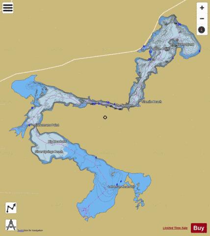
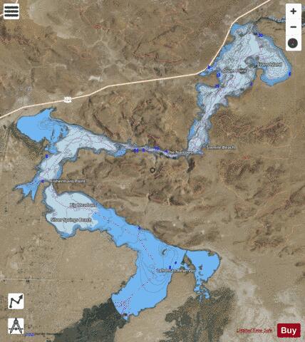
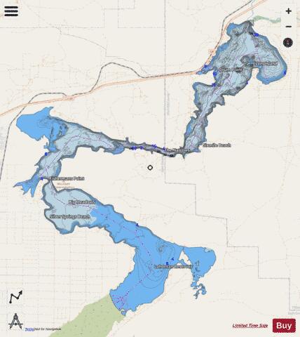
Lahontan Reservoir Fishing Map Stats | |
| Title | Lahontan Reservoir |
| Scale | 1:12000 |
| Counties | Churchill, Lyon |
| Nearby Cities | Silver Springs, Hazen, Stagecoach, Wabuska, Fernley, Wadsworth, Fallon, Yerington, Weed Heights, Patrick |
| Area * | 9998.99 acres |
| Shoreline * | 76.97 miles |
| Min Longitude | -119.21 |
| Min Latitude | 39.33 |
| Max Longitude | -119.05 |
| Max Latitude | 39.46 |
| Edition Label 1 | |
| Edition Label 2 | |
| Edition Label 3 | |
| Id | US_UB_NV_lahontan_reservoir |
| Country | US |
| Projection | Mercator |
| * some Stats may include nearby/connecting waterbodies | |
|