Chevelon Canyon Lake fishing map is available as part of iBoating : USA Marine & Fishing App(now supported on multiple platforms including Android, iPhone/iPad, MacBook, and Windows(tablet and phone)/PC based chartplotter.).
With our Lake Maps App, you get all the great marine chart app features like fishing spots, along with Chevelon Canyon Lake depth map. The fishing maps app include HD lake depth contours, along with advanced features found in Fish Finder / Gps Chart Plotter systems, turning your device into a Depth Finder. The Chevelon Canyon Lake Navigation App provides advanced features of a Marine Chartplotter including adjusting water level offset and custom depth shading. Fishing spots and depth contours layers are available in most Lake maps. Lake navigation features include advanced instrumentation to gather wind speed direction, water temperature, water depth, and accurate GPS with AIS receivers(using NMEA over TCP/UDP). Autopilot support can be enabled during ‘Goto WayPoint’ and ‘Route Assistance’.
Now i-Boating supports Fishing Points in Chevelon Canyon Lake.
Have more questions about the Nautical Chart App? Ask us.
Fishing Info for Chevelon Canyon Lake
Chevelon Canyon Lake is a small reservoir located in northern Arizona, about 28 mi (45 km) northwest of the town of Heber. It is one in a series of small, canyon-bound lakes located on the Mogollon Rim, collectively referred to as the Rim Lakes. It is said to be among the most difficult to access in the region. It is also the second reservoir on Chevelon Creek, downstream from Woods Canyon Lake. The facilities are maintained by Apache–Sitgreaves National Forests division of the USDA Forest Service.
More on Wikipedia...Popular fish species in this lake include Arctic grayling and Rainbow trout.
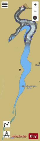
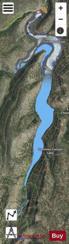
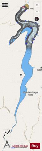
Chevelon Canyon Lake Fishing Map Stats | |
| Title | Chevelon Canyon Lake |
| Scale | 1:1500 |
| Counties | Coconino |
| Nearby Cities | Forest Lakes Estates, Heber, Christopher Creek, Overgaard, Kohls Ranch, Tonto Village, Young, Aripine, Washington Park, Star Valley |
| Area * | 226.07 acres |
| Shoreline * | 7.95 miles |
| Min Longitude | -110.83 |
| Min Latitude | 34.47 |
| Max Longitude | -110.82 |
| Max Latitude | 34.51 |
| Edition Label 1 | |
| Edition Label 2 | |
| Edition Label 3 | |
| Id | US_AA_AZ_chevelon_canyon_lake_az |
| Country | US |
| Projection | Mercator |
| * some Stats may include nearby/connecting waterbodies | |
|