Coyote Lake fishing map is available as part of iBoating : USA Marine & Fishing App(now supported on multiple platforms including Android, iPhone/iPad, MacBook, and Windows(tablet and phone)/PC based chartplotter.).
With our Lake Maps App, you get all the great marine chart app features like fishing spots, along with Coyote Lake depth map. The fishing maps app include HD lake depth contours, along with advanced features found in Fish Finder / Gps Chart Plotter systems, turning your device into a Depth Finder. The Coyote Lake Navigation App provides advanced features of a Marine Chartplotter including adjusting water level offset and custom depth shading. Fishing spots and depth contours layers are available in most Lake maps. Lake navigation features include advanced instrumentation to gather wind speed direction, water temperature, water depth, and accurate GPS with AIS receivers(using NMEA over TCP/UDP). Autopilot support can be enabled during ‘Goto WayPoint’ and ‘Route Assistance’.
Now i-Boating supports Fishing Points in Coyote Lake.
Have more questions about the Nautical Chart App? Ask us.
Fishing Info for Coyote Lake
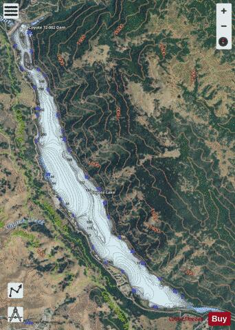
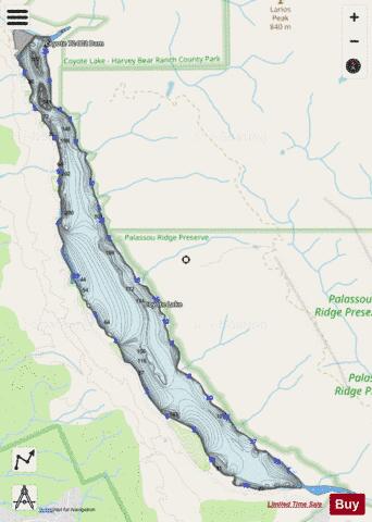
Coyote Lake (also known as Coyote Reservoir) is an artificial lake in Santa Clara County, California, between Morgan Hill and Gilroy. The reservoir is impounded by Coyote Dam, a 140-foot (43 m) high, 980-foot (300 m) long, earth and rock dam built in 1936. It holds 23,244 acre feet (28,671,009 m3) of water when full. It is the second largest reservoir owned by the Santa Clara Valley Water District. A 4,595-acre county park ("Coyote-Bear") surrounds the reservoir, and provides camping (RVs and tents), fishing ("catch-and-release"), picnicking, and hiking activities. Swimming is not allowed by order of the Santa Clara Valley Water District. Power boating, jetskiing, waterskiing, sailing, canoeing/kayaking and fishing are all allowed in the reservoir. The boat launch ramp is located two miles north of the visitor center. It has two docks, a 3-lane concrete ramp, paved parking and a restroom. For fisherman, the lake contains bluegill, black crappie, channel catfish, carp and black bass. The reservoir is closed to all boating between mid-October and mid-April. The California Office of Environmental Health Hazard Assessment has issued a safe eating advisory for any fish caught in the Coyote lake due to elevated levels of mercury.
More on Wikipedia...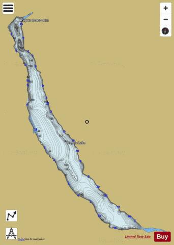
Coyote Lake Fishing Map Stats | |
| Title | Coyote Lake |
| Scale | 1:6000 |
| Counties | Santa Clara |
| Nearby Cities | San Martin, Gilroy, Morgan Hill, Aromas, San Juan Bautista, Interlaken, Hollister, Freedom, Pajaro, Watsonville |
| Area * | 570.00 acres |
| Shoreline * | 8.87 miles |
| Min Longitude | -121.55 |
| Min Latitude | 37.08 |
| Max Longitude | -121.51 |
| Max Latitude | 37.12 |
| Edition Label 1 | |
| Edition Label 2 | |
| Edition Label 3 | |
| Id | US_AA_CA_coyote_lake_ca |
| Country | US |
| Projection | Mercator |
| * some Stats may include nearby/connecting waterbodies | |
|