Council Bluff Lake fishing map is available as part of iBoating : USA Marine & Fishing App(now supported on multiple platforms including Android, iPhone/iPad, MacBook, and Windows(tablet and phone)/PC based chartplotter.).
With our Lake Maps App, you get all the great marine chart app features like fishing spots, along with Council Bluff Lake depth map. The fishing maps app include HD lake depth contours, along with advanced features found in Fish Finder / Gps Chart Plotter systems, turning your device into a Depth Finder. The Council Bluff Lake Navigation App provides advanced features of a Marine Chartplotter including adjusting water level offset and custom depth shading. Fishing spots and depth contours layers are available in most Lake maps. Lake navigation features include advanced instrumentation to gather wind speed direction, water temperature, water depth, and accurate GPS with AIS receivers(using NMEA over TCP/UDP). Autopilot support can be enabled during ‘Goto WayPoint’ and ‘Route Assistance’.
Now i-Boating supports Fishing Points in Council Bluff Lake.
Have more questions about the Nautical Chart App? Ask us.
Fishing Info for Council Bluff Lake
Council Bluff Lake is a lake in Mark Twain National Forest in Iron County, Missouri. It is 440 acres in area. Some parts of the lake are 87 feet deep. The lake was created when Big River was dammed. The Council Bluff Dam construction began in 1979 and was completed in 1981. It was at the time the largest earthfill dam ever built by the USDA-Forest Service with an embankment height of 124 feet.
More on Wikipedia...Popular fish species in this lake include Largemouth bass and Redear sunfish.

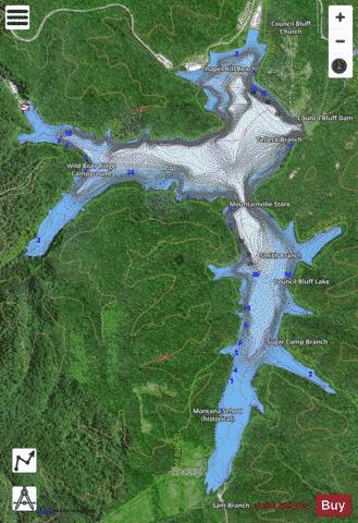
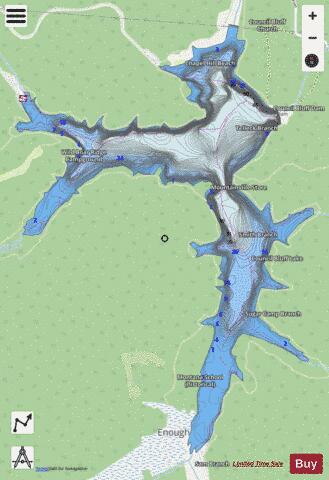
Council Bluff Lake Fishing Map Stats | |
| Title | Council Bluff Lake |
| Scale | 1:6000 |
| Counties | Iron |
| Nearby Cities | Belgrade, Caledonia, Belleview, Black, Shirley, Bixby, Viburnum, Potosi, Irondale, Lesterville |
| Area * | 429.12 acres |
| Shoreline * | 10.86 miles |
| Min Longitude | -90.93 |
| Min Latitude | 37.71 |
| Max Longitude | -90.90 |
| Max Latitude | 37.74 |
| Edition Label 1 | |
| Edition Label 2 | |
| Edition Label 3 | |
| Id | US_AA_MO_council_bluff_lake__mo |
| Country | US |
| Projection | Mercator |
| * some Stats may include nearby/connecting waterbodies | |
|