Lake Mattamuskeet fishing map is available as part of iBoating : USA Marine & Fishing App(now supported on multiple platforms including Android, iPhone/iPad, MacBook, and Windows(tablet and phone)/PC based chartplotter.).
With our Lake Maps App, you get all the great marine chart app features like fishing spots, along with Lake Mattamuskeet depth map. The fishing maps app include HD lake depth contours, along with advanced features found in Fish Finder / Gps Chart Plotter systems, turning your device into a Depth Finder. The Lake Mattamuskeet Navigation App provides advanced features of a Marine Chartplotter including adjusting water level offset and custom depth shading. Fishing spots and depth contours layers are available in most Lake maps. Lake navigation features include advanced instrumentation to gather wind speed direction, water temperature, water depth, and accurate GPS with AIS receivers(using NMEA over TCP/UDP). Autopilot support can be enabled during ‘Goto WayPoint’ and ‘Route Assistance’.
Have more questions about the Nautical Chart App? Ask us.
Fishing Info for Lake Mattamuskeet
Lake Mattamuskeet is the largest natural lake in North Carolina. It is a shallow coastal lake, averaging 2–3 ft (0.61–0.91 m) feet in depth, and stretches 18 miles (29 km) long and 7 miles (11 km) wide. Lake Mattamuskeet lies on the Albemarle-Pamlico Peninsula. Lake Mattamuskeet is the location of Mattamuskeet National Wildlife Refuge. This refuge as well as surrounding public and private lands in eastern North Carolina are a major wintering site for waterfowl including ducks like northern pintail and green-wing teal, geese like Canada geese and tundra swans.
More on Wikipedia...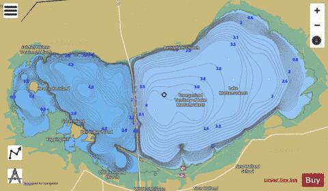
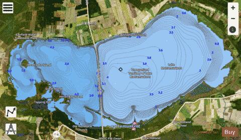
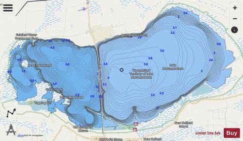
Lake Mattamuskeet Fishing Map Stats | |
| Title | Lake Mattamuskeet |
| Scale | 1:12000 |
| Counties | Hyde |
| Nearby Cities | Fairfield, Engelhard, Swanquarter, Kilkenny, Pamlico Beach, Belhaven, Lowland, Hobucken, Creswell, Pike Road |
| Area * | 40494.64 acres |
| Shoreline * | 91.39 miles |
| Min Longitude | -76.32 |
| Min Latitude | 35.45 |
| Max Longitude | -76.06 |
| Max Latitude | 35.56 |
| Edition Label 1 | |
| Edition Label 2 | |
| Edition Label 3 | |
| Id | US_AA_NC_lake_mattamuskeet__nc |
| Country | US |
| Projection | Mercator |
| * some Stats may include nearby/connecting waterbodies | |
|