Goey Pond fishing map is available as part of iBoating : USA Marine & Fishing App(now supported on multiple platforms including Android, iPhone/iPad, MacBook, and Windows(tablet and phone)/PC based chartplotter.).
With our Lake Maps App, you get all the great marine chart app features like fishing spots, along with Goey Pond depth map. The fishing maps app include HD lake depth contours, along with advanced features found in Fish Finder / Gps Chart Plotter systems, turning your device into a Depth Finder. The Goey Pond Navigation App provides advanced features of a Marine Chartplotter including adjusting water level offset and custom depth shading. Fishing spots and depth contours layers are available in most Lake maps. Lake navigation features include advanced instrumentation to gather wind speed direction, water temperature, water depth, and accurate GPS with AIS receivers(using NMEA over TCP/UDP). Autopilot support can be enabled during ‘Goto WayPoint’ and ‘Route Assistance’.
Now i-Boating supports Fishing Points in Goey Pond.
Have more questions about the Nautical Chart App? Ask us.
Fishing Info for Goey Pond
Goey Pond or Goey's Pond (also known as Little Pond) is a small lake located northwest of the Village of Milford in the Town of Hartwick in Otsego County, New York. The pond is only accessible from one road (Goey Pond Road), which is not maintained during the winter months. No dwellings line the lake. Fish species present in the pond are largemouth bass, smallmouth bass, pumpkinseed, chain pickerel, and brown bullhead. Goey Pond is 47 feet deep at its center. (A natural formation, the pond was at one point dammed, which increased its depth by approximately 15 to 25 feet.) Historically, the pond was the drinking water source for the village of Milford. It was first surveyed in 1965. In 1967, Milford applied for a grant to extend a pipeline deeper into the pond. Currently, Milford does not use Goey Pond as a water supply, but retains possession of the pond, "which may be developed in the future to serve as sources of the water supply to the Village of Milford." As such, bathing, swimming, boating, fishing, and trespassing are officially prohibited at the pond.
More on Wikipedia...Popular fish species in this lake include Brown bullhead, Chain pickerel, Largemouth bass, Pumpkinseed and Smallmouth bass.
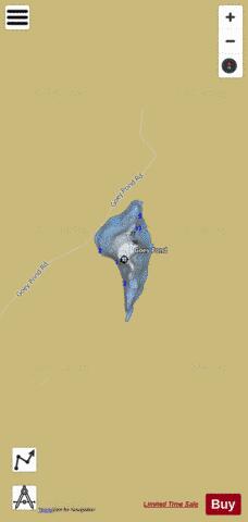
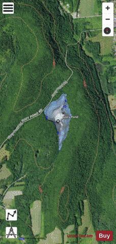
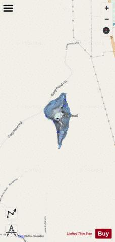
Goey Pond Fishing Map Stats | |
| Title | Goey Pond |
| Scale | 1:6000 |
| Counties | Otsego |
| Nearby Cities | Milford, Hartwick, Cooperstown, Maryland, Middlefield, Laurens, Schuyler Lake, Schenevus, Westford, Burlington |
| Area * | 35.77 acres |
| Shoreline * | 1.22 miles |
| Min Longitude | -74.98 |
| Min Latitude | 42.62 |
| Max Longitude | -74.97 |
| Max Latitude | 42.63 |
| Edition Label 1 | |
| Edition Label 2 | |
| Edition Label 3 | |
| Id | US_AA_NY_goey_pond_ny |
| Country | US |
| Projection | Mercator |
| * some Stats may include nearby/connecting waterbodies | |
|