Lake Neatahwanta fishing map is available as part of iBoating : USA Marine & Fishing App(now supported on multiple platforms including Android, iPhone/iPad, MacBook, and Windows(tablet and phone)/PC based chartplotter.).
With our Lake Maps App, you get all the great marine chart app features like fishing spots, along with Lake Neatahwanta depth map. The fishing maps app include HD lake depth contours, along with advanced features found in Fish Finder / Gps Chart Plotter systems, turning your device into a Depth Finder. The Lake Neatahwanta Navigation App provides advanced features of a Marine Chartplotter including adjusting water level offset and custom depth shading. Fishing spots and depth contours layers are available in most Lake maps. Lake navigation features include advanced instrumentation to gather wind speed direction, water temperature, water depth, and accurate GPS with AIS receivers(using NMEA over TCP/UDP). Autopilot support can be enabled during ‘Goto WayPoint’ and ‘Route Assistance’.
Now i-Boating supports Fishing Points in Lake Neatahwanta.
Have more questions about the Nautical Chart App? Ask us.
Fishing Info for Lake Neatahwanta
Lake Neatahwanta is located in and near the city of Fulton in Oswego County, New York. It covers approximately 750 acres (3.0 km2) of which about one-half is located within the city, while the other half is located in the town of Granby. Neatahwanta translates to "little lake near the big lake" in Iroquois. It is currently prohibited to swim in the lake or to allow pets to have contact with the water due to pollution and microbial growth. It is currently being dredged in hope to have it open for public use again. It is expected to be fully clean in about 2 years.
More on Wikipedia...Popular fish species in this lake include Black bullhead, Black crappie, Bowfin, Largemouth bass, Northern pike, Striped bass and Yellow perch.
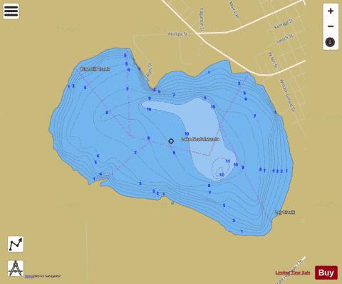
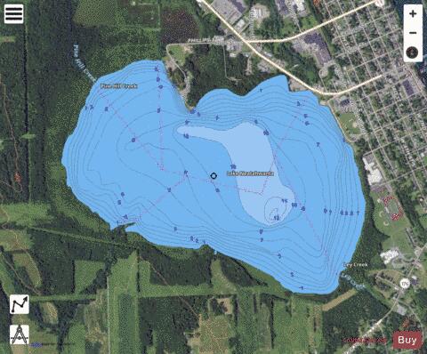
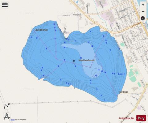
Lake Neatahwanta Fishing Map Stats | |
| Title | Lake Neatahwanta |
| Scale | 1:12000 |
| Counties | Oswego |
| Nearby Cities | Fulton, Volney, Minetto, Lysander, Hannibal, Ira, Phoenix, Scriba, Palermo, Oswego |
| Area * | 775.92 acres |
| Shoreline * | 4.97 miles |
| Min Longitude | -76.45 |
| Min Latitude | 43.30 |
| Max Longitude | -76.42 |
| Max Latitude | 43.32 |
| Edition Label 1 | |
| Edition Label 2 | |
| Edition Label 3 | |
| Id | US_AA_NY_lake_neatahwanta_ny |
| Country | US |
| Projection | Mercator |
| * some Stats may include nearby/connecting waterbodies | |
|