Lake Ronkonkoma fishing map is available as part of iBoating : USA Marine & Fishing App(now supported on multiple platforms including Android, iPhone/iPad, MacBook, and Windows(tablet and phone)/PC based chartplotter.).
With our Lake Maps App, you get all the great marine chart app features like fishing spots, along with Lake Ronkonkoma depth map. The fishing maps app include HD lake depth contours, along with advanced features found in Fish Finder / Gps Chart Plotter systems, turning your device into a Depth Finder. The Lake Ronkonkoma Navigation App provides advanced features of a Marine Chartplotter including adjusting water level offset and custom depth shading. Fishing spots and depth contours layers are available in most Lake maps. Lake navigation features include advanced instrumentation to gather wind speed direction, water temperature, water depth, and accurate GPS with AIS receivers(using NMEA over TCP/UDP). Autopilot support can be enabled during ‘Goto WayPoint’ and ‘Route Assistance’.
Now i-Boating supports Fishing Points in Lake Ronkonkoma.
Have more questions about the Nautical Chart App? Ask us.
Fishing Info for Lake Ronkonkoma
Lake Ronkonkoma is a freshwater lake in Suffolk County, New York. It is a kettle lake formed by retreating glaciers and is the largest freshwater lake on Long Island; it has a circumference of about 2 miles (3.2 km) and is 0.65 miles (1.05 km) across on average.The lake is owned by the Town of Islip under the terms of the Nichols Patent. The land around it is controlled by three town governments – Smithtown, Islip and Brookhaven. The separation originated because three different Native American communities claimed lands on different shores, and these claims continued when the tribes gave separate deeds to the land under their control. The name Ronkonkoma comes from an Algonquian expression meaning "boundary fishing-lake", also earlier written as Raconkumake and Raconkamuck.
More on Wikipedia...Popular fish species in this lake include Black crappie, Brown bullhead, Chain pickerel, Largemouth bass, Pacu, Pumpkinseed, Smallmouth bass, Tiger muskellunge, Walleye and Yellow perch.
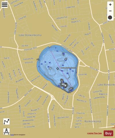
Lake Ronkonkoma Fishing Map Stats | |
| Title | Lake Ronkonkoma |
| Scale | 1:3000 |
| Counties | Suffolk |
| Nearby Cities | Lake Ronkonkoma, Ronkonkoma, Lake Grove, Centereach, Nesconset, Holbrook, Islandia, Bohemia, Saint James, Village of the Branch |
| Area * | 226.31 acres |
| Shoreline * | 2.28 miles |
| Min Longitude | -73.13 |
| Min Latitude | 40.82 |
| Max Longitude | -73.12 |
| Max Latitude | 40.83 |
| Edition Label 1 | |
| Edition Label 2 | |
| Edition Label 3 | |
| Id | US_AA_NY_lake_ronkonkoma_ny |
| Country | US |
| Projection | Mercator |
| * some Stats may include nearby/connecting waterbodies | |
|