Upper St Regis Lake fishing map is available as part of iBoating : USA Marine & Fishing App(now supported on multiple platforms including Android, iPhone/iPad, MacBook, and Windows(tablet and phone)/PC based chartplotter.).
With our Lake Maps App, you get all the great marine chart app features like fishing spots, along with Upper St Regis Lake depth map. The fishing maps app include HD lake depth contours, along with advanced features found in Fish Finder / Gps Chart Plotter systems, turning your device into a Depth Finder. The Upper St Regis Lake Navigation App provides advanced features of a Marine Chartplotter including adjusting water level offset and custom depth shading. Fishing spots and depth contours layers are available in most Lake maps. Lake navigation features include advanced instrumentation to gather wind speed direction, water temperature, water depth, and accurate GPS with AIS receivers(using NMEA over TCP/UDP). Autopilot support can be enabled during ‘Goto WayPoint’ and ‘Route Assistance’.
Now i-Boating supports Fishing Points in Upper St Regis Lake.
Have more questions about the Nautical Chart App? Ask us.
Fishing Info for Upper St Regis Lake
742-acre (3.00 km2) Upper St. Regis Lake is a part of the St. Regis River in the Adirondacks in northern New York State. Along with Lower St. Regis Lake and Spitfire Lake, it became famous in the late 19th century as a summer playground of America's power elite, drawn to the area by its scenic beauty and by the rustic charms of Paul Smith's Hotel. It is the site of many grand old summer "cottages" and Great Camps, including Marjorie Merriweather Post's Topridge. Frederick W. Vanderbilt, Anson Phelps Stokes and Whitelaw Reid were among the summer residents. "The camps of many of these families began as tent colonies, with separate units for sleeping, dining, games, and so on, and evolved into permanent structures built with understated taste." Apollos "Paul" Smith started his hotel in 1859 as a primitive operation that appealed to sportsmen. Gradually, the hotel became something of a fad amongst the wealthy and powerful of New York. As camping became more of a family activity, Smith would allow families to set up camp for day use along the shores of the St. Regis Lakes, returning to the hotel for the night. Eventually, families would lease or buy land from Smith and build tent platforms, and finally clusters of cabins and cottages. Even in the early stages, some of these camps became quite elaborate. In 1883, one of the first families, the Stokes, would arrive in a "special parlour horse car direct from 42nd street to Ausable for $100." The party consisted of ten family members and an equal number of servants, "three horses, two dogs, one carriage, five large boxes of tents, three cases of wine, two packages of stovepipe, two stoves, one bale of china, one iron pot, four washstands, one barrel of hardware, four bundles of poles, seventeen cots and seventeen mattresses, four canvas packages, one buckboard, [...], twenty-five trunks, thirteen small boxes, one boat, one hamper", all of which was then transferred to wagons for the 36-mile (58 km) ride to Paul Smiths, and thence by boat to their island campsite. Upper Saint Regis Lake is part of the original Seven Carries canoe route from Paul Smith's Hotel to Saranac Inn. It is also the original home of the Idem-class racing sailboats, originally built in 1900, the oldest class of actively racing one-design boats with original boats participating. The lake is located in the towns of Harrietstown and Brighton, both in Franklin County, New York. * Camp Katia * The boathouse at Camp Katia. * Another boathouse at Topridge. * An Adirondack guideboat. * Billiard Room, Camp Wild Air * Bishops Palace, Camp Wild Air
More on Wikipedia...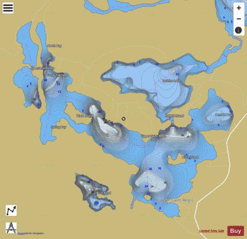
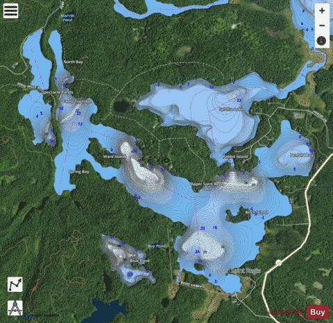
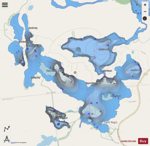
Upper St Regis Lake Fishing Map Stats | |
| Title | Upper St Regis Lake |
| Scale | 1:12000 |
| Counties | Franklin |
| Nearby Cities | Paul Smiths, Lake Clear, Harrietstown, Saranac Lake, Loon Lake, Tupper Lake, Santa Clara, Lake Placid, Piercefield, North Elba |
| Area * | 808.77 acres |
| Shoreline * | 15.16 miles |
| Min Longitude | -74.30 |
| Min Latitude | 44.40 |
| Max Longitude | -74.26 |
| Max Latitude | 44.43 |
| Edition Label 1 | |
| Edition Label 2 | |
| Edition Label 3 | |
| Id | US_AA_NY_upper_st__regis_lake_ny |
| Country | US |
| Projection | Mercator |
| * some Stats may include nearby/connecting waterbodies | |
|