Shenango River Lake fishing map is available as part of iBoating : USA Marine & Fishing App(now supported on multiple platforms including Android, iPhone/iPad, MacBook, and Windows(tablet and phone)/PC based chartplotter.).
With our Lake Maps App, you get all the great marine chart app features like fishing spots, along with Shenango River Lake depth map. The fishing maps app include HD lake depth contours, along with advanced features found in Fish Finder / Gps Chart Plotter systems, turning your device into a Depth Finder. The Shenango River Lake Navigation App provides advanced features of a Marine Chartplotter including adjusting water level offset and custom depth shading. Fishing spots and depth contours layers are available in most Lake maps. Lake navigation features include advanced instrumentation to gather wind speed direction, water temperature, water depth, and accurate GPS with AIS receivers(using NMEA over TCP/UDP). Autopilot support can be enabled during ‘Goto WayPoint’ and ‘Route Assistance’.
Now i-Boating supports Fishing Points in Shenango River Lake.
Have more questions about the Nautical Chart App? Ask us.
Fishing Info for Shenango River Lake
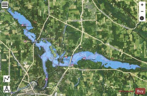
Shenango River Lake is a reservoir in the Shenango River Valley of western Pennsylvania and northeastern Ohio. Authorized by the Flood Control Acts of 1938, the lake is one of 16 flood control projects in the Pittsburgh District designed to prevent flooding. It is a popular site among anglers and is lined by 330 campsites. The concrete Shenango Dam (National ID # PA00111) was completed in 1965, at a height of 68 feet and a length of 720 feet at its crest, as a flood control project of the United States Army Corps of Engineers. The reservoir has a maximum capacity of 351,000 acre-feet, and a normal capacity of 29,920 acre-feet.
More on Wikipedia...Popular fish species in this lake include Largemouth Bass, Panfish and Smallmouth Bass.
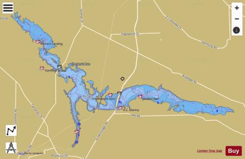
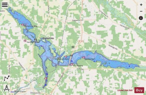
Shenango River Lake Fishing Map Stats | |
| Title | Shenango River Lake |
| Scale | 1:24000 |
| Counties | Mercer |
| Nearby Cities | Clark, Orangeville, Sharpsville, Hermitage, Reynolds Heights, Sharon, Farrell, Wheatland, Fredonia, West Middlesex |
| Area * | 3485.42 acres |
| Shoreline * | 56.04 miles |
| Min Longitude | -80.51 |
| Min Latitude | 41.26 |
| Max Longitude | -80.34 |
| Max Latitude | 41.34 |
| Edition Label 1 | |
| Edition Label 2 | |
| Edition Label 3 | |
| Id | US_AA_PA_01046181 |
| Country | US |
| Projection | Mercator |
| * some Stats may include nearby/connecting waterbodies | |
|