Lake Quinault fishing map is available as part of iBoating : USA Marine & Fishing App(now supported on multiple platforms including Android, iPhone/iPad, MacBook, and Windows(tablet and phone)/PC based chartplotter.).
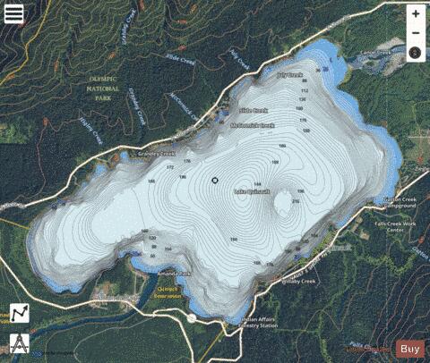
With our Lake Maps App, you get all the great marine chart app features like fishing spots, along with Lake Quinault depth map. The fishing maps app include HD lake depth contours, along with advanced features found in Fish Finder / Gps Chart Plotter systems, turning your device into a Depth Finder. The Lake Quinault Navigation App provides advanced features of a Marine Chartplotter including adjusting water level offset and custom depth shading. Fishing spots and depth contours layers are available in most Lake maps. Lake navigation features include advanced instrumentation to gather wind speed direction, water temperature, water depth, and accurate GPS with AIS receivers(using NMEA over TCP/UDP). Autopilot support can be enabled during ‘Goto WayPoint’ and ‘Route Assistance’.
Now i-Boating supports Fishing Points in Lake Quinault.
Have more questions about the Nautical Chart App? Ask us.
Fishing Info for Lake Quinault
Lake Quinault (/kwɪˈnɒlt/ or /kwɪˈnɔːlt/) is a lake on the Olympic Peninsula in western Washington state. It is located in the glacial-carved Quinault Valley of the Quinault River, at the southern edge of Olympic National Park in the northwestern United States. One of the most dominant features of Lake Quinault is its location within the Quinault Rainforest, a temperate rain forest. Lake Quinault is owned by the Quinault Indian Nation. The area is accessible from U.S. Route 101. Area activities include fishing (with permit from the Quinaults), scenic drives (a loop around the lake is longer than 30 miles (48 km)), and hiking. The southern side of the lake features a system of short hiking trails maintained by the U.S. Forest Service that are accessible to casual day hikers. The southern side of the lake is home to the historic Lake Quinault Lodge and the Rain Forest Resort Village and is encompassed by the Olympic National Forest. The Quinault Loop Trail on the south side of the lake and the nearby Quinault Rain Forest Interpretive Trail connecting campgrounds, trails, and the lodge, with excellent temperate rainforest viewing. Each trail was designated a National Recreation Trail in 1979. The north side of the lake is bordered mainly by private homes and some small resorts located in Olympic National Park. Lake Quinault receives an average of 332.92 centimeters (131.07 inches) of precipitation per year.
More on Wikipedia...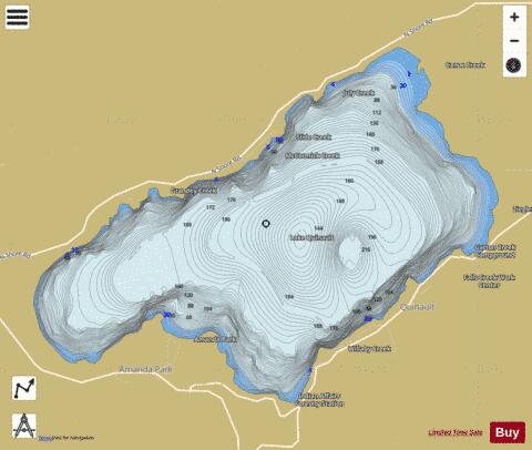
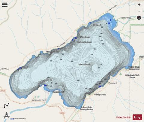
Lake Quinault Fishing Map Stats | |
| Title | Lake Quinault |
| Scale | 1:24000 |
| Counties | Grays Harbor |
| Nearby Cities | Amanda Park, Quinault, Neilton, Humptulips, Grisdale, Carlisle, Moclips, Pacific Beach, Copalis Crossing, Taholah |
| Area * | 3544.98 acres |
| Shoreline * | 12.55 miles |
| Min Longitude | -123.91 |
| Min Latitude | 47.46 |
| Max Longitude | -123.83 |
| Max Latitude | 47.50 |
| Edition Label 1 | |
| Edition Label 2 | |
| Edition Label 3 | |
| Id | US_AA_WA_lake_quinault_wa |
| Country | US |
| Projection | Mercator |
| * some Stats may include nearby/connecting waterbodies | |
|