Lake Samish fishing map is available as part of iBoating : USA Marine & Fishing App(now supported on multiple platforms including Android, iPhone/iPad, MacBook, and Windows(tablet and phone)/PC based chartplotter.).
With our Lake Maps App, you get all the great marine chart app features like fishing spots, along with Lake Samish depth map. The fishing maps app include HD lake depth contours, along with advanced features found in Fish Finder / Gps Chart Plotter systems, turning your device into a Depth Finder. The Lake Samish Navigation App provides advanced features of a Marine Chartplotter including adjusting water level offset and custom depth shading. Fishing spots and depth contours layers are available in most Lake maps. Lake navigation features include advanced instrumentation to gather wind speed direction, water temperature, water depth, and accurate GPS with AIS receivers(using NMEA over TCP/UDP). Autopilot support can be enabled during ‘Goto WayPoint’ and ‘Route Assistance’.
Now i-Boating supports Fishing Points in Lake Samish.
Have more questions about the Nautical Chart App? Ask us.
Fishing Info for Lake Samish
Lake Samish (/ˈsæmɪʃ/ SAM-ish) is a lake south of Bellingham, Washington, United States. Visible to the west of Interstate 5 when travelling between Alger and Bellingham, Lake Samish is heavily used for recreation in the summer months by local residents. The lake shoreline is heavily developed and homesites cover almost the entire shoreline. Lake Samish is bordered on the south by Blanchard Mountain and on the north by Chuckanut Pass. Public access is limited but a Whatcom County park with a rough boat launch is located along the northern shore. In pre-colonial days, members of the Samish tribe lived at sites on the lake. In 1873 the Northern Pacific Railway Company made a preliminary survey through the Lake Samish valley on the way to Bellingham Bay and Hudson's Bay Company trappers had also probably been through the area before that but the first Europeans to settle at Lake Samish were Charlie Barns and William Harris, who staked claims to 160 acres each in March/April 1885, Barns on the east side and Harris on the west side of the lake. In 1931, a new highway connecting Seattle to Vancouver was constructed on the east side of the lake and designated part of U.S. Route 99. This road was later replaced by Interstate 5. Notable residents include Hilary Swank, who grew up on a trailer park next to the lake, and Ryan Stiles, who lives next to the lake.
More on Wikipedia...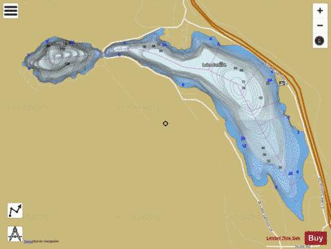
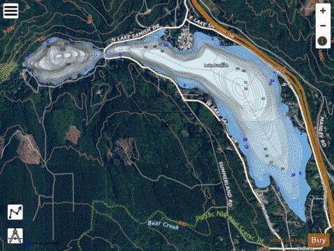
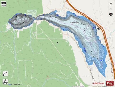
Lake Samish Fishing Map Stats | |
| Title | Lake Samish |
| Scale | 1:12000 |
| Counties | Whatcom |
| Nearby Cities | Alger, Samish, Blanchard, Geneva, Bow, Edison, Bellingham, Wickersham, Acme, Burlington |
| Area * | 811.92 acres |
| Shoreline * | 8.55 miles |
| Min Longitude | -122.43 |
| Min Latitude | 48.65 |
| Max Longitude | -122.37 |
| Max Latitude | 48.67 |
| Edition Label 1 | |
| Edition Label 2 | |
| Edition Label 3 | |
| Id | US_AA_WA_lake_samish_wa |
| Country | US |
| Projection | Mercator |
| * some Stats may include nearby/connecting waterbodies | |
|