Pelican Lake fishing map is available as part of iBoating : USA Marine & Fishing App(now supported on multiple platforms including Android, iPhone/iPad, MacBook, and Windows(tablet and phone)/PC based chartplotter.).
With our Lake Maps App, you get all the great marine chart app features like fishing spots, along with Pelican Lake depth map. The fishing maps app include HD lake depth contours, along with advanced features found in Fish Finder / Gps Chart Plotter systems, turning your device into a Depth Finder. The Pelican Lake Navigation App provides advanced features of a Marine Chartplotter including adjusting water level offset and custom depth shading. Fishing spots and depth contours layers are available in most Lake maps. Lake navigation features include advanced instrumentation to gather wind speed direction, water temperature, water depth, and accurate GPS with AIS receivers(using NMEA over TCP/UDP). Autopilot support can be enabled during ‘Goto WayPoint’ and ‘Route Assistance’.
Now i-Boating supports Fishing Points in Pelican Lake.
Have more questions about the Nautical Chart App? Ask us.
Fishing Info for Pelican Lake
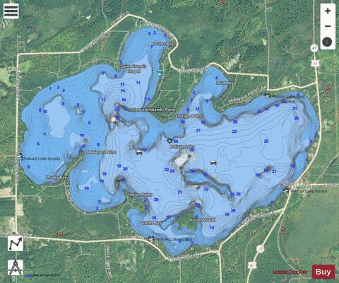
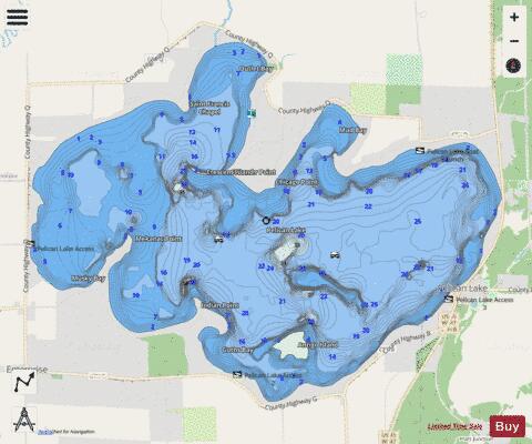
Pelican Lake is a 3,585-acre (14.51 km2) lake located in Oneida County in Wisconsin. It has a maximum depth of 39 ft (12 m). Visitors have access to the lake from five public boat landings. A dam is located on the lake's primary outlet, which feeds into the Pelican River. Pelican Lake serves as one of 21 reservoirs used to regulate and maintain optimal water flow on the Wisconsin and Tomahawk rivers, the process of which is facilitated in part by the Wisconsin Valley Improvement Company. Fish inhabiting the lake include muskie, panfish, largemouth bass, smallmouth bass, northern pike and walleye. The lake's water clarity has historically been low, and its bottom composition is 40% sand, 20% gravel, 10% rock, 30% muck. The lake is eutrophic. Several invasive species are or have been found in the lake, including banded mystery snail, Chinese mystery snail, curly-leaf pondweed, Eurasian water-milfoil, purple loosestrife, and rusty crayfish. Pelican Lake was named for the American white pelicans seen there. In the Ojibwe language, the lake goes by either Zhede-zaaga'igan (pelican lake) or more commonly as Gaa-wabaataawangaag-zaaga'igan (place where there is a sandy narrows lake).
More on Wikipedia...Popular fish species in this lake include Largemouth bass, Northern pike, Panfish, Smallmouth bass and Walleye.
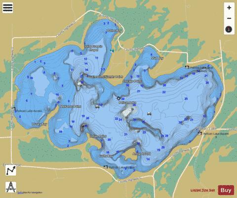
Pelican Lake Fishing Map Stats | |
| Title | Pelican Lake |
| Scale | 1:24000 |
| Counties | Oneida |
| Nearby Cities | Pelican Lake, Enterprise, Elcho, Monico, Post Lake, Summit Lake, Gagen, Mole Lake, Parrish, Kempster |
| Area * | 3547.34 acres |
| Shoreline * | 16.29 miles |
| Min Longitude | -89.24 |
| Min Latitude | 45.49 |
| Max Longitude | -89.16 |
| Max Latitude | 45.53 |
| Edition Label 1 | |
| Edition Label 2 | |
| Edition Label 3 | |
| Id | US_AA_WI_01571152 |
| Country | US |
| Projection | Mercator |
| * some Stats may include nearby/connecting waterbodies | |
|