Lake Lou Yaeger fishing map is available as part of iBoating : USA Marine & Fishing App(now supported on multiple platforms including Android, iPhone/iPad, MacBook, and Windows(tablet and phone)/PC based chartplotter.).
With our Lake Maps App, you get all the great marine chart app features like fishing spots, along with Lake Lou Yaeger depth map. The fishing maps app include HD lake depth contours, along with advanced features found in Fish Finder / Gps Chart Plotter systems, turning your device into a Depth Finder. The Lake Lou Yaeger Navigation App provides advanced features of a Marine Chartplotter including adjusting water level offset and custom depth shading. Fishing spots and depth contours layers are available in most Lake maps. Lake navigation features include advanced instrumentation to gather wind speed direction, water temperature, water depth, and accurate GPS with AIS receivers(using NMEA over TCP/UDP). Autopilot support can be enabled during ‘Goto WayPoint’ and ‘Route Assistance’.
Now i-Boating supports Fishing Points in Lake Lou Yaeger.
Have more questions about the Nautical Chart App? Ask us.
Fishing Info for Lake Lou Yaeger
Lake Lou Yaeger is a 1,300-acre (5.2 km²) reservoir located in Montgomery County, Illinois. Created by damming the West Fork of Illinois's Shoal Creek, it was built for recreation, sport fishing, and flood control purposes. The lake is 8 miles (13 km) long and 0.5 miles (0.8 km) wide. The nearest town is Litchfield, Illinois, south of Springfield, Illinois and north of St. Louis, Missouri. Lake Lou Yaeger is managed for bass, bluegill, catfish, and crappie. The fish yield is enjoyed by many species; bald eagles began to nest at the lake in 2005. Boaters enjoy the absence of both speed and power limits such as are enforced on many other lakes in central and southern Illinois. Visitors to the lake often arrive by means of Interstate 55, which closely approaches the lake north of Litchfield. The municipality of Litchfield operates the lake's largest park, the 266-acre (1.1 km²) Shoal Creek Conservation Area. The park contains patches of oak-hickory woodland and some patches of prairie, locally called prairie "barrens." There are 1.15 miles (1.8 km) of trails for foot, bike, or horse use.
More on Wikipedia...Popular fish species in this lake include Crappie.
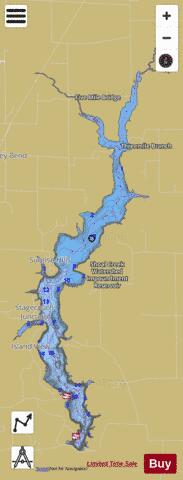
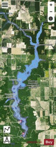
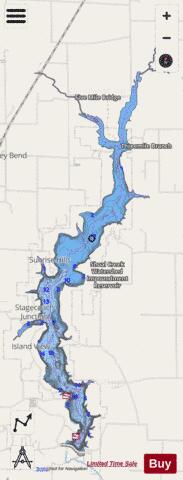
Lake Lou Yaeger Fishing Map Stats | |
| Title | Lake Lou Yaeger |
| Scale | 1:12000 |
| Counties | Montgomery |
| Nearby Cities | Raymond, Litchfield, Butler, Harvel, Hillsboro, Waggoner, Walshville, Taylor Springs, Schram City, Lake Ka-Ho |
| Area * | 1369.33 acres |
| Shoreline * | 32.15 miles |
| Min Longitude | -89.62 |
| Min Latitude | 39.19 |
| Max Longitude | -89.57 |
| Max Latitude | 39.28 |
| Edition Label 1 | |
| Edition Label 2 | |
| Edition Label 3 | |
| Id | US_CC_IL_lou_yaeger_lake_il |
| Country | US |
| Projection | Mercator |
| * some Stats may include nearby/connecting waterbodies | |
|