Wrightsville fishing map is available as part of iBoating : USA Marine & Fishing App(now supported on multiple platforms including Android, iPhone/iPad, MacBook, and Windows(tablet and phone)/PC based chartplotter.).
With our Lake Maps App, you get all the great marine chart app features like fishing spots, along with Wrightsville lake depth map. The fishing maps app include HD lake depth contours, along with advanced features found in Fish Finder / Gps Chart Plotter systems, turning your device into a Depth Finder. The Wrightsville Navigation App provides advanced features of a Marine Chartplotter including adjusting water level offset and custom depth shading. Fishing spots and depth contours layers are available in most Lake maps. Lake navigation features include advanced instrumentation to gather wind speed direction, water temperature, water depth, and accurate GPS with AIS receivers(using NMEA over TCP/UDP). Autopilot support can be enabled during ‘Goto WayPoint’ and ‘Route Assistance’.
Now i-Boating supports Fishing Points in Wrightsville.
Have more questions about the Nautical Chart App? Ask us.
Fishing Info for Wrightsville
Wrightsville Reservoir is a reservoir located in Washington County, Vermont. It is located at the intersection of the municipal borders of three towns, Montpelier, Middlesex, and East Montpelier. It is a popular recreational spot in the summer, for swimming, boating, and fishing in the Montpelier area. While it most of the area of the lake is owned by the town of Middlesex, it is closer to Montpelier and is usually accessed from Vermont Route 12. It has a popular swimming beach with a disk golf course and a boat launch, both near Route 12.
More on Wikipedia...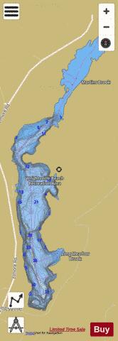
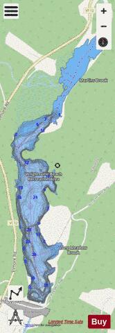
Wrightsville Fishing Map Stats | |
| Title | Wrightsville |
| Scale | 1:1500 |
| Counties | Washington |
| Nearby Cities | Worcester, Montpelier, East Montpelier, Middlesex, Barre, Plainfield, South Barre, Stowe, Duxbury, Waterbury |
| Area * | 180.50 acres |
| Shoreline * | 6.25 miles |
| Min Longitude | -72.58 |
| Min Latitude | 44.31 |
| Max Longitude | -72.56 |
| Max Latitude | 44.34 |
| Edition Label 1 | |
| Edition Label 2 | |
| Edition Label 3 | |
| Id | US_CC_VT_biobase_wrightsville_vt_19 |
| Country | US |
| Projection | Mercator |
| * some Stats may include nearby/connecting waterbodies | |
|