Lake Wazee fishing map is available as part of iBoating : USA Marine & Fishing App(now supported on multiple platforms including Android, iPhone/iPad, MacBook, and Windows(tablet and phone)/PC based chartplotter.).
With our Lake Maps App, you get all the great marine chart app features like fishing spots, along with Lake Wazee depth map. The fishing maps app include HD lake depth contours, along with advanced features found in Fish Finder / Gps Chart Plotter systems, turning your device into a Depth Finder. The Lake Wazee Navigation App provides advanced features of a Marine Chartplotter including adjusting water level offset and custom depth shading. Fishing spots and depth contours layers are available in most Lake maps. Lake navigation features include advanced instrumentation to gather wind speed direction, water temperature, water depth, and accurate GPS with AIS receivers(using NMEA over TCP/UDP). Autopilot support can be enabled during ‘Goto WayPoint’ and ‘Route Assistance’.
Now i-Boating supports Fishing Points in Lake Wazee.
Have more questions about the Nautical Chart App? Ask us.
Fishing Info for Lake Wazee
Wazee Lake is a lake east of Black River Falls, Wisconsin, in the town of Brockway, Jackson County, Wisconsin, United States. The name "Wazee" means "tall pine" in the Ho-Chunk language. The artificial lake is the deepest lake within the state of Wisconsin, with a maximum depth of approximately 355 feet (108 m). The man-made lake was formed after the site was used as a quarry for taconite mining between the mid-1960s through April 1983. The quarry produced about 850,000 tons of taconite pellets each year. The mine closed in 1983 as a result of a crash of the domestic steel markets in the United States. When the mine was in operation, pumps removed about 800 US gallons (3,000 L; 670 imp gal) of water per minute from the quarry. Once these pumps were shut down, the quarry began filling with water. The lake is now part of a county park known as Wazee Lake Recreation Area. The lake is a prime scuba diving destination because of its deep, clear water. Visibility averages between 30 feet (9.1 m) and 40 feet (12 m) during the summer months. There are also visible remains of mining operations underwater, such as roadways used for hauling equipment. Some features have been added to the lake, such as underwater platforms for training divers and fish cribs to improve habitat for the fish. Fish species within the lake include rainbow, brook, and brown trout, bluegills, suckers, catfish, walleye, warmouth, and smallmouth bass.
More on Wikipedia...Popular fish species in this lake include Brook trout, Catostomidae, Rainbow trout, Smallmouth bass, Walleye and Warmouth.
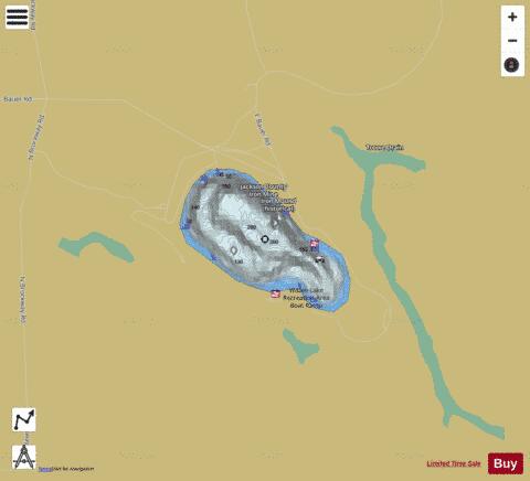
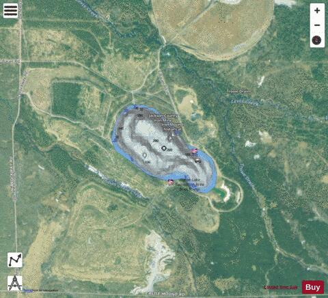
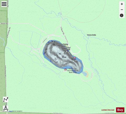
Lake Wazee Fishing Map Stats | |
| Title | Lake Wazee |
| Scale | 1:3000 |
| Counties | Jackson |
| Nearby Cities | Brockway, Vaudreuil, Millston, Hatfield, Black River Falls, Merrillan, Cataract, Alma Center, Irving, Warrens |
| Area * | 138.45 acres |
| Shoreline * | 1.96 miles |
| Min Longitude | -90.73 |
| Min Latitude | 44.29 |
| Max Longitude | -90.72 |
| Max Latitude | 44.29 |
| Edition Label 1 | |
| Edition Label 2 | |
| Edition Label 3 | |
| Id | US_CC_WI_wazee_wi |
| Country | US |
| Projection | Mercator |
| * some Stats may include nearby/connecting waterbodies | |
|