SAWGRASS LAKE fishing map is available as part of iBoating : USA Marine & Fishing App(now supported on multiple platforms including Android, iPhone/iPad, MacBook, and Windows(tablet and phone)/PC based chartplotter.).
With our Lake Maps App, you get all the great marine chart app features like fishing spots, along with SAWGRASS LAKE depth map. The fishing maps app include HD lake depth contours, along with advanced features found in Fish Finder / Gps Chart Plotter systems, turning your device into a Depth Finder. The SAWGRASS LAKE Navigation App provides advanced features of a Marine Chartplotter including adjusting water level offset and custom depth shading. Fishing spots and depth contours layers are available in most Lake maps. Lake navigation features include advanced instrumentation to gather wind speed direction, water temperature, water depth, and accurate GPS with AIS receivers(using NMEA over TCP/UDP). Autopilot support can be enabled during ‘Goto WayPoint’ and ‘Route Assistance’.
Now i-Boating supports Fishing Points in SAWGRASS LAKE.
Have more questions about the Nautical Chart App? Ask us.
Fishing Info for SAWGRASS LAKE
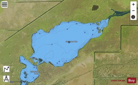
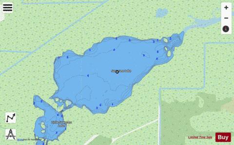
Sawgrass Lake is a lake in Brevard County, Florida, United States. It is one of the lakes that form the St. Johns River. The lake is usually accessed by boat from a ramp located on U.S. Route 192 on the west shore of the St. Johns River. The lake is located near the river's headwaters, and the size of the lake is limited by the low velocity of the river at this point. It is only 4 miles (6.4 km) in diameter with a surface area of less than 1,000 acres (4 km2). The lake is only 3 miles (4.8 km) upstream from Lake Washington, the county's largest lake. Governed by the St. Johns Water Management District.
More on Wikipedia...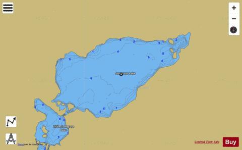
SAWGRASS LAKE Fishing Map Stats | |
| Title | SAWGRASS LAKE |
| Scale | 1:6000 |
| 1 ft Depth Contours for Anglers | Yes |
| Counties | Brevard |
| Nearby Cities | June Park, Melbourne Village, Deer Park, West Melbourne, Eau Gallie, Palm Shores, Melbourne, Pineda, Palm Bay, Indian Harbour Beach |
| Area * | 484.56 acres |
| Shoreline * | 5.76 miles |
| Min Longitude | -80.79 |
| Min Latitude | 28.07 |
| Max Longitude | -80.76 |
| Max Latitude | 28.08 |
| Edition Label 1 | |
| Edition Label 2 | |
| Edition Label 3 | |
| Id | US_FL_00290715 |
| Country | US |
| Projection | Mercator |
| * some Stats may include nearby/connecting waterbodies | |
|