Burnsville fishing map is available as part of iBoating : USA Marine & Fishing App(now supported on multiple platforms including Android, iPhone/iPad, MacBook, and Windows(tablet and phone)/PC based chartplotter.).
With our Lake Maps App, you get all the great marine chart app features like fishing spots, along with Burnsville lake depth map. The fishing maps app include HD lake depth contours, along with advanced features found in Fish Finder / Gps Chart Plotter systems, turning your device into a Depth Finder. The Burnsville Navigation App provides advanced features of a Marine Chartplotter including adjusting water level offset and custom depth shading. Fishing spots and depth contours layers are available in most Lake maps. Lake navigation features include advanced instrumentation to gather wind speed direction, water temperature, water depth, and accurate GPS with AIS receivers(using NMEA over TCP/UDP). Autopilot support can be enabled during ‘Goto WayPoint’ and ‘Route Assistance’.
Now i-Boating supports Fishing Points in Burnsville.
Have more questions about the Nautical Chart App? Ask us.
Fishing Info for Burnsville
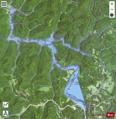
Burnsville Lake is both a recreational and flood control reservoir on Little Kanawha River located southeast of Burnsville in Braxton County, West Virginia. Burnsville Lake was authorized by the U.S. Congress in the Flood Control Act of 1938. Construction of the Burnsville Lake project was begun in the summer of 1972 and the dam was completed in September 1976. The lake project controls the runoff from a drainage area of 165 square miles (427 km²). The dam is a rock-fill embankment dam rising 84.5 feet (25.8 m) above the streambed. Top elevation is 839 feet (256 m) above sea level, and the crest length is 1,400 feet (430 m). A gated spillway is located in the left abutment. The outlet works are located in the spillway section. The minimum pool is maintained at elevation 776 feet (237 m) with a surface area of 550 acres (223 ha). The summer pool is at elevation 789 feet (240 m) and has a surface area of 968 acres (392 ha). The flood control pool is at elevation 825 feet (251 m) with a surface area of 1,900 acres (769 ha). Many people in Burnsville and surrounding communities opposed the building of the dam since the back waters would flood areas currently occupied and locations of ancestral homes. Cemeteries had to be moved and residents had to relocate. When the dam was built, there was no recreation area for local residents instead residents of Burnsville had to travel to Bulltown.
More on Wikipedia...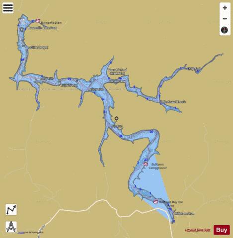
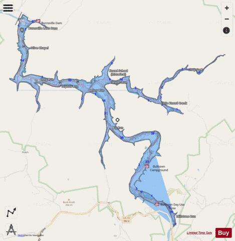
Burnsville Fishing Map Stats | |
| Title | Burnsville |
| Scale | 1:12000 |
| Counties | Braxton |
| Nearby Cities | Orlando, Burnsville, Ireland, Walkersville, Flatwoods, Sand Fork, Sutton, Cleveland, Frenchton, Alum Bridge |
| Area * | 896.21 acres |
| Shoreline * | 32.09 miles |
| Min Longitude | -80.62 |
| Min Latitude | 38.78 |
| Max Longitude | -80.55 |
| Max Latitude | 38.84 |
| Edition Label 1 | |
| Edition Label 2 | |
| Edition Label 3 | |
| Id | US_WV_wvdn_burnsville |
| Country | US |
| Projection | Mercator |
| * some Stats may include nearby/connecting waterbodies | |
|