Echo Lake fishing map is available as part of iBoating : USA Marine & Fishing App(now supported on multiple platforms including Android, iPhone/iPad, MacBook, and Windows(tablet and phone)/PC based chartplotter.).
With our Lake Maps App, you get all the great marine chart app features like fishing spots, along with Echo Lake depth map. The fishing maps app include HD lake depth contours, along with advanced features found in Fish Finder / Gps Chart Plotter systems, turning your device into a Depth Finder. The Echo Lake Navigation App provides advanced features of a Marine Chartplotter including adjusting water level offset and custom depth shading. Fishing spots and depth contours layers are available in most Lake maps. Lake navigation features include advanced instrumentation to gather wind speed direction, water temperature, water depth, and accurate GPS with AIS receivers(using NMEA over TCP/UDP). Autopilot support can be enabled during ‘Goto WayPoint’ and ‘Route Assistance’.
Now i-Boating supports Fishing Points in Echo Lake.
Have more questions about the Nautical Chart App? Ask us.
Fishing Info for Echo Lake
Echo Lake, also known as Crotched Pond, is a lake located in the towns of Fayette, Mount Vernon and Readfield, Maine. It is 117 feet (36 m) deep, and covers about 1.9 square miles (5 km2) in surface area. One of the major bodies of water in the Winthrop Lakes Region, the lake is known for its rocky shores, scenery, deep cool water, and naturally reproducing lake trout population. A public boat launch is located on the north shore in Mount Vernon off State Route #41. Camp Winnebago, a summer camp for boys, is located on the southwest shore of Echo Lake.
More on Wikipedia...Popular fish species in this lake include Lake trout.
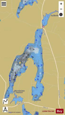
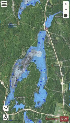
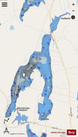
Echo Lake Fishing Map Stats | |
| Title | Echo Lake |
| Scale | 1:6000 |
| Counties | Kennebec |
| Nearby Cities | Fayette, Mount Vernon, Readfield, Wayne, Vienna, Winthrop, Chesterville, Leeds, Livermore Falls, Chisholm |
| Area * | 1235.18 acres |
| Shoreline * | 20.65 miles |
| Min Longitude | -70.05 |
| Min Latitude | 44.41 |
| Max Longitude | -70.00 |
| Max Latitude | 44.46 |
| Edition Label 1 | |
| Edition Label 2 | |
| Edition Label 3 | |
| Id | US_ME_00565769 |
| Country | US |
| Projection | Mercator |
| * some Stats may include nearby/connecting waterbodies | |
|