Gravel Lake fishing map is available as part of iBoating : USA Marine & Fishing App(now supported on multiple platforms including Android, iPhone/iPad, MacBook, and Windows(tablet and phone)/PC based chartplotter.).
With our Lake Maps App, you get all the great marine chart app features like fishing spots, along with Gravel Lake depth map. The fishing maps app include HD lake depth contours, along with advanced features found in Fish Finder / Gps Chart Plotter systems, turning your device into a Depth Finder. The Gravel Lake Navigation App provides advanced features of a Marine Chartplotter including adjusting water level offset and custom depth shading. Fishing spots and depth contours layers are available in most Lake maps. Lake navigation features include advanced instrumentation to gather wind speed direction, water temperature, water depth, and accurate GPS with AIS receivers(using NMEA over TCP/UDP). Autopilot support can be enabled during ‘Goto WayPoint’ and ‘Route Assistance’.
Now i-Boating supports Fishing Points in Gravel Lake.
Have more questions about the Nautical Chart App? Ask us.
Fishing Info for Gravel Lake
Gravel Lake is a 296-acre (1.20 km2) freshwater lake in the southeast corner of Porter Township near the southern boundary of Van Buren County in the U.S. state of Michigan. The lake is located between Lawton and Marcellus. The lake is controlled and managed by a homeowners association, the Gravel Lake Association. Located in the southwestern part of the state, the lake is spring fed and has an outlet (spillway) on Idle Ease beach which feeds Saddlebag Lake (and Big Fish Lake) and an inlet from a swamp named Strawberry Lake just behind the northern end of Idle Ease Beach. Gravel Lake is popular for fishing in the area and the lake contains northern pike, largemouth & smallmouth bass, bluegill, yellow perch, bullhead, white sucker, bowfin, black crappie, and some walleye. This lake also has a strong bond amongst its residents and many traditions take place every year. Memorial Day Weekend and Labor Day Weekend host many activities, but the most popular is Fourth of July. The Gravel Lake Association sponsors The Paddle Boat Regatta, The 2 Mile Fun Run/Walk, The Boat Parade, and The Kids' Games.
More on Wikipedia...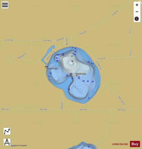
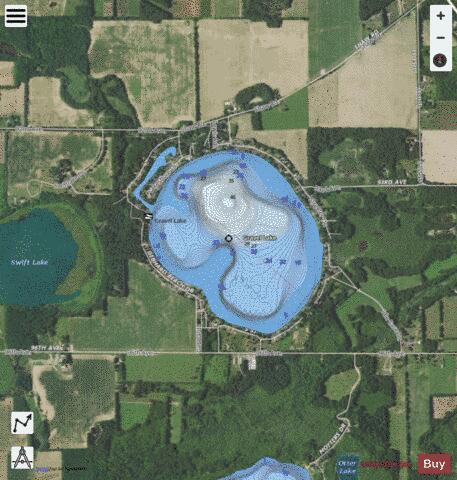
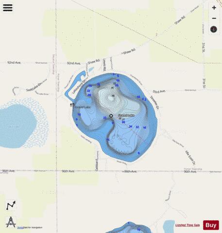
Gravel Lake Fishing Map Stats | |
| Title | Gravel Lake |
| Scale | 1:12000 |
| Includes Data from Fish Atlas | Yes |
| Counties | Van Buren |
| Nearby Cities | Marcellus, Lawton, Decatur, Paw Paw, Mattawan, Vandalia, Cassopolis, Lawrence, Schoolcraft, Dowagiac |
| Area * | 297.40 acres |
| Shoreline * | 3.27 miles |
| Min Longitude | -85.88 |
| Min Latitude | 42.07 |
| Max Longitude | -85.86 |
| Max Latitude | 42.08 |
| Edition Label 1 | |
| Edition Label 2 | |
| Edition Label 3 | |
| Id | US_MI_80_281 |
| Country | US |
| Projection | Mercator |
| * some Stats may include nearby/connecting waterbodies | |
|