Quake Lake fishing map is available as part of iBoating : USA Marine & Fishing App(now supported on multiple platforms including Android, iPhone/iPad, MacBook, and Windows(tablet and phone)/PC based chartplotter.).
With our Lake Maps App, you get all the great marine chart app features like fishing spots, along with Quake Lake depth map. The fishing maps app include HD lake depth contours, along with advanced features found in Fish Finder / Gps Chart Plotter systems, turning your device into a Depth Finder. The Quake Lake Navigation App provides advanced features of a Marine Chartplotter including adjusting water level offset and custom depth shading. Fishing spots and depth contours layers are available in most Lake maps. Lake navigation features include advanced instrumentation to gather wind speed direction, water temperature, water depth, and accurate GPS with AIS receivers(using NMEA over TCP/UDP). Autopilot support can be enabled during ‘Goto WayPoint’ and ‘Route Assistance’.
Now i-Boating supports Fishing Points in Quake Lake.
Have more questions about the Nautical Chart App? Ask us.
Fishing Info for Quake Lake
Quake Lake (officially Earthquake Lake) is a lake in the western United States, on the Madison River in southwestern Montana. It was created after an earthquake struck on August 17, 1959, with 28 fatalities. Northwest of West Yellowstone, Quake Lake is six miles (10 km) in length with a maximum depth of 125 feet (38 m). U.S. Route 287 follows the lake and offers glimpses of the effects of the earthquake and landslide, and a visitor center is just off the road. The lake is mostly within Gallatin National Forest.
More on Wikipedia...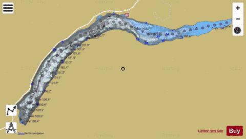
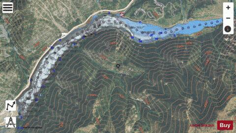
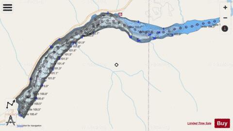
Quake Lake Fishing Map Stats | |
| Title | Quake Lake |
| Scale | 1:12000 |
| Counties | Gallatin, Madison |
| Nearby Cities | Grayling, West Yellowstone, Big Springs, Island Park, Big Sky, Cameron, Lakeview, Miner, Jeffers, Ennis |
| Area * | 614.31 acres |
| Shoreline * | 9.48 miles |
| Min Longitude | -111.42 |
| Min Latitude | 44.83 |
| Max Longitude | -111.35 |
| Max Latitude | 44.86 |
| Edition Label 1 | |
| Edition Label 2 | |
| Edition Label 3 | |
| Id | US_MT_mtfwp_1113877448522_mt |
| Country | US |
| Projection | Mercator |
| * some Stats may include nearby/connecting waterbodies | |
|