Lake Luzerne fishing map is available as part of iBoating : USA Marine & Fishing App(now supported on multiple platforms including Android, iPhone/iPad, MacBook, and Windows(tablet and phone)/PC based chartplotter.).
With our Lake Maps App, you get all the great marine chart app features like fishing spots, along with Lake Luzerne depth map. The fishing maps app include HD lake depth contours, along with advanced features found in Fish Finder / Gps Chart Plotter systems, turning your device into a Depth Finder. The Lake Luzerne Navigation App provides advanced features of a Marine Chartplotter including adjusting water level offset and custom depth shading. Fishing spots and depth contours layers are available in most Lake maps. Lake navigation features include advanced instrumentation to gather wind speed direction, water temperature, water depth, and accurate GPS with AIS receivers(using NMEA over TCP/UDP). Autopilot support can be enabled during ‘Goto WayPoint’ and ‘Route Assistance’.
Now i-Boating supports Fishing Points in Lake Luzerne.
Have more questions about the Nautical Chart App? Ask us.
Fishing Info for Lake Luzerne
Lake Luzerne is a lake in the town of Lake Luzerne, New York. Fish species present in the lake are northern pike, smallmouth bass, largemouth bass, rainbow trout, brown trout, rock bass, bluegill, yellow perch, pumpkinseed sunfish, brown bullhead, and chain pickerel. There is a boat launch on the west shore off County Route 9. The lake contains multiple beaches available to the public including Wayside Beach. Ice fishing tournaments occur in the wintertime and vehicles can be driven on the ice. A small bridge is located just near the beach where people will jump off into the water. This is dangerous because the water is not very deep in this location. Ivy Island is the sole island in the lake. Access to the island is prohibited without permission from the town of Lake Luzerne. A trespassing fine of $250 has been imposed. According to local lore, the island is so named because of the presence of poison ivy.
More on Wikipedia...Popular fish species in this lake include Brown bullhead, Chain pickerel, Largemouth bass, Northern pike, Rainbow trout, Rock bass, Smallmouth bass and Yellow perch.
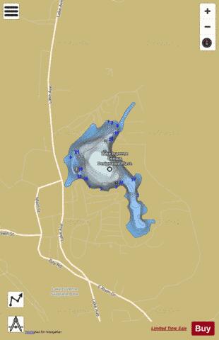

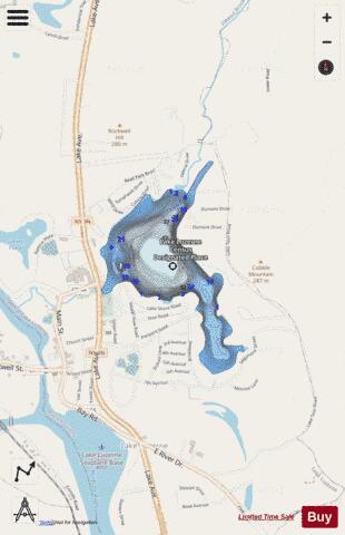
Lake Luzerne Fishing Map Stats | |
| Title | Lake Luzerne |
| Scale | 1:3000 |
| Counties | Warren |
| Nearby Cities | Lake Luzerne, Hadley, Corinth, Stony Creek, West Glens Falls, Lake George, Wilton, Warrensburg, Glens Falls, Greenfield |
| Area * | 99.37 acres |
| Shoreline * | 2.99 miles |
| Min Longitude | -73.84 |
| Min Latitude | 43.32 |
| Max Longitude | -73.83 |
| Max Latitude | 43.33 |
| Edition Label 1 | |
| Edition Label 2 | |
| Edition Label 3 | |
| Id | US_NY_1104_0075 |
| Country | US |
| Projection | Mercator |
| * some Stats may include nearby/connecting waterbodies | |
|