Lake Carl Albert fishing map is available as part of iBoating : USA Marine & Fishing App(now supported on multiple platforms including Android, iPhone/iPad, MacBook, and Windows(tablet and phone)/PC based chartplotter.).
With our Lake Maps App, you get all the great marine chart app features like fishing spots, along with Lake Carl Albert depth map. The fishing maps app include HD lake depth contours, along with advanced features found in Fish Finder / Gps Chart Plotter systems, turning your device into a Depth Finder. The Lake Carl Albert Navigation App provides advanced features of a Marine Chartplotter including adjusting water level offset and custom depth shading. Fishing spots and depth contours layers are available in most Lake maps. Lake navigation features include advanced instrumentation to gather wind speed direction, water temperature, water depth, and accurate GPS with AIS receivers(using NMEA over TCP/UDP). Autopilot support can be enabled during ‘Goto WayPoint’ and ‘Route Assistance’.
Now i-Boating supports Fishing Points in Lake Carl Albert.
Have more questions about the Nautical Chart App? Ask us.
Fishing Info for Lake Carl Albert
Lake Carl Albert is a reservoir in Latimer County, Oklahoma, United States. The lake was formed as a result of the Scs-Rock Creek Site-02 dam on Rock Creek and is used for flood control, drinking water and recreation purposes. Construction was completed in 1964. Its normal surface area is 183 acres (74 ha). It is owned by the town of Talihina.
More on Wikipedia...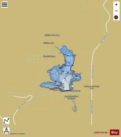
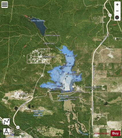
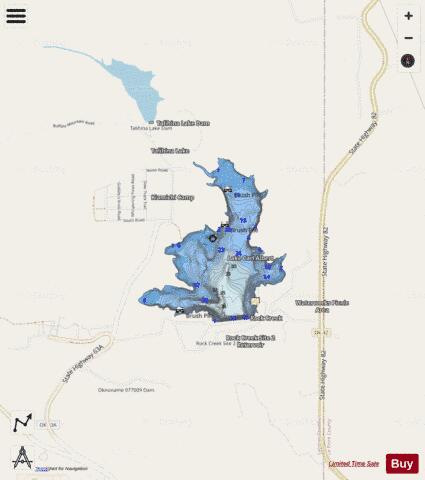
Lake Carl Albert Fishing Map Stats | |
| Title | Lake Carl Albert |
| Scale | 1:6000 |
| Counties | Latimer |
| Nearby Cities | Talihina, Albion, Leflore, Whitesboro, Red Oak, Fanshawe, Honobia, Yanush, Tuskahoma, Wilburton |
| Area * | 161.97 acres |
| Shoreline * | 4.08 miles |
| Min Longitude | -95.08 |
| Min Latitude | 34.77 |
| Max Longitude | -95.06 |
| Max Latitude | 34.78 |
| Edition Label 1 | |
| Edition Label 2 | |
| Edition Label 3 | |
| Id | US_OK_carlalbert |
| Country | US |
| Projection | Mercator |
| * some Stats may include nearby/connecting waterbodies | |
|