CorpusChristi fishing map is available as part of iBoating : USA Marine & Fishing App(now supported on multiple platforms including Android, iPhone/iPad, MacBook, and Windows(tablet and phone)/PC based chartplotter.).
With our Lake Maps App, you get all the great marine chart app features like fishing spots, along with CorpusChristi lake depth map. The fishing maps app include HD lake depth contours, along with advanced features found in Fish Finder / Gps Chart Plotter systems, turning your device into a Depth Finder. The CorpusChristi Navigation App provides advanced features of a Marine Chartplotter including adjusting water level offset and custom depth shading. Fishing spots and depth contours layers are available in most Lake maps. Lake navigation features include advanced instrumentation to gather wind speed direction, water temperature, water depth, and accurate GPS with AIS receivers(using NMEA over TCP/UDP). Autopilot support can be enabled during ‘Goto WayPoint’ and ‘Route Assistance’.
Now i-Boating supports Fishing Points in CorpusChristi.
Have more questions about the Nautical Chart App? Ask us.
Fishing Info for CorpusChristi
Lake Corpus Christi is a reservoir in coastal southern Texas. The lake was created by impoundment of the Nueces River by the Wesley E. Seale Dam opened in 1958. The lake and the dam that creates it are managed by the City of Corpus Christi. Lake Corpus Christi was originally known as Lake Lovenskiold. It is often referred to as Lake Mathis because of its location.
More on Wikipedia...Popular fish species in this lake include Alligator gar, Crappie, Largemouth bass, Lepomis and White bass.
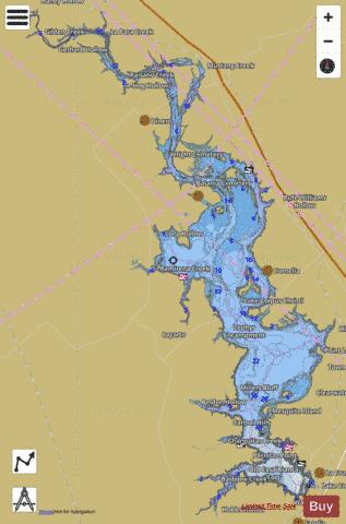


CorpusChristi Fishing Map Stats | |
| Title | CorpusChristi |
| Scale | 1:24000 |
| Counties | Jim Wells, Live Oak, San Patricio |
| Nearby Cities | Lakeside, Lake City, Pernitas Point, Dinero, Sandia, Mathis, Orange Grove, George West, Tynan, San Patricio |
| Area * | 18827.40 acres |
| Shoreline * | 232.22 miles |
| Min Longitude | -98.04 |
| Min Latitude | 28.03 |
| Max Longitude | -97.85 |
| Max Latitude | 28.28 |
| Edition Label 1 | |
| Edition Label 2 | |
| Edition Label 3 | |
| Id | US_TX_corpuschristi |
| Country | US |
| Projection | Mercator |
| * some Stats may include nearby/connecting waterbodies | |
|