Abiquiu Lake fishing map is available as part of iBoating : USA Marine & Fishing App(now supported on multiple platforms including Android, iPhone/iPad, MacBook, and Windows(tablet and phone)/PC based chartplotter.).
With our Lake Maps App, you get all the great marine chart app features like fishing spots, along with Abiquiu Lake depth map. The fishing maps app include HD lake depth contours, along with advanced features found in Fish Finder / Gps Chart Plotter systems, turning your device into a Depth Finder. The Abiquiu Lake Navigation App provides advanced features of a Marine Chartplotter including adjusting water level offset and custom depth shading. Fishing spots and depth contours layers are available in most Lake maps. Lake navigation features include advanced instrumentation to gather wind speed direction, water temperature, water depth, and accurate GPS with AIS receivers(using NMEA over TCP/UDP). Autopilot support can be enabled during ‘Goto WayPoint’ and ‘Route Assistance’.
Now i-Boating supports Fishing Points in Abiquiu Lake.
Have more questions about the Nautical Chart App? Ask us.
Fishing Info for Abiquiu Lake
Abiquiu Lake is a reservoir located in Rio Arriba County, in northern New Mexico in the southwestern United States. Water of the Rio Chama is impounded by the earth-filled Abiquiu Dam, 1,800 feet (550 m) long and 340 feet (104 m) high, completed in 1963 and raised in 1986. The 5,200-acre (21 km2) lake is over 12 miles (20 km) long, and lies at elevations of 6,100–6,220 feet (1,859–1,896 m). The shoreline area near the dam is a recreation area managed by the US Army Corps of Engineers (USACE). Available activities include camping, picnicking, hiking, swimming, boating, and fishing. * Location in New Mexico * Abiquiu Dam * Abiquiu Lake
More on Wikipedia...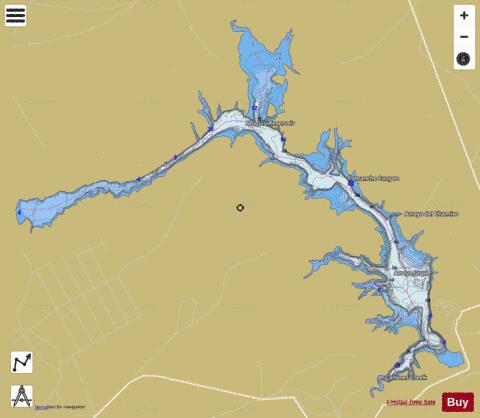
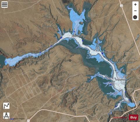
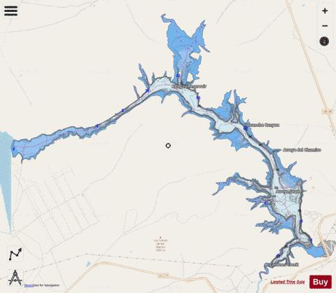
Abiquiu Lake Fishing Map Stats | |
| Title | Abiquiu Lake |
| Scale | 1:12000 |
| Counties | Rio Arriba |
| Nearby Cities | Cañones, Youngsville, Abiquiu, Coyote, Canjilon, Alire, Cebolla, Medanales, El Rito, Gallina |
| Area * | 1739.41 acres |
| Shoreline * | 36.75 miles |
| Min Longitude | -106.52 |
| Min Latitude | 36.23 |
| Max Longitude | -106.43 |
| Max Latitude | 36.30 |
| Edition Label 1 | |
| Edition Label 2 | |
| Edition Label 3 | |
| Id | US_UB_NM_00923786 |
| Country | US |
| Projection | Mercator |
| * some Stats may include nearby/connecting waterbodies | |
|