Shawano Lake fishing map is available as part of iBoating : USA Marine & Fishing App(now supported on multiple platforms including Android, iPhone/iPad, MacBook, and Windows(tablet and phone)/PC based chartplotter.).
With our Lake Maps App, you get all the great marine chart app features like fishing spots, along with Shawano Lake depth map. The fishing maps app include HD lake depth contours, along with advanced features found in Fish Finder / Gps Chart Plotter systems, turning your device into a Depth Finder. The Shawano Lake Navigation App provides advanced features of a Marine Chartplotter including adjusting water level offset and custom depth shading. Fishing spots and depth contours layers are available in most Lake maps. Lake navigation features include advanced instrumentation to gather wind speed direction, water temperature, water depth, and accurate GPS with AIS receivers(using NMEA over TCP/UDP). Autopilot support can be enabled during ‘Goto WayPoint’ and ‘Route Assistance’.
Now i-Boating supports Fishing Points in Shawano Lake.
Have more questions about the Nautical Chart App? Ask us.
Fishing Info for Shawano Lake
Shawano Lake is a lake situated in Shawano County in northeastern Wisconsin. Shawano Lake is a hard water drainage lake with multiple inlets and one major outlet, the Wolf River. A dam on the Wolf River located in the City of Shawano raises the water levels of Shawano Lake. Shawano Lake is approximately 6,178 acres (25.00 km2), with an average depth of approximately 9 feet (2.7 m) and a maximum depth of approximately 42 feet (13 m). The shoreline length is estimated at 18 miles (29 km). The Towns of Wescott, and Washington, and the Village of Cecil border Shawano Lake.
More on Wikipedia...Popular fish species in this lake include Black crappie, Largemouth bass, Northern pike, Pumpkinseed, Walleye and Yellow perch.
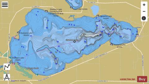
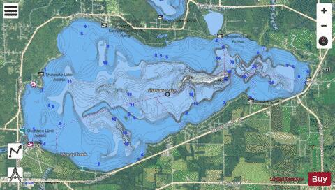
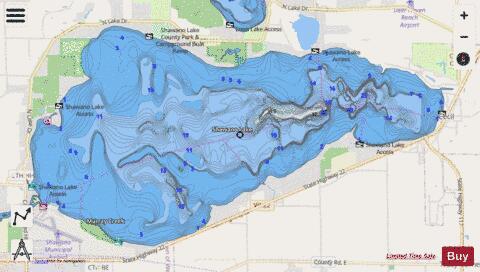
Shawano Lake Fishing Map Stats | |
| Title | Shawano Lake |
| Scale | 1:12000 |
| Counties | Shawano |
| Nearby Cities | Cecil, Shawano, Bonduel, Legend Lake, Lunds, Underhill, Pulcifer, Keshena, Thornton, Belle Plaine |
| Area * | 6220.40 acres |
| Shoreline * | 18.50 miles |
| Min Longitude | -88.57 |
| Min Latitude | 44.78 |
| Max Longitude | -88.45 |
| Max Latitude | 44.83 |
| Edition Label 1 | |
| Edition Label 2 | |
| Edition Label 3 | |
| Id | US_UB_WI_01573979 |
| Country | US |
| Projection | Mercator |
| * some Stats may include nearby/connecting waterbodies | |
|