i-Boating client for Android now supports AIS(Automatic Identification System) target display and instruments data on the map.
- Setting up AIS/NMEA Client
- Using linktype TCP
- Using linktype UDP
- AIS Targets display on Map
- Using GPS over NMEA
- Wind, sonar, temperature and other instruments data
- Supported AIS Receivers/Instruments
- NMEA over TCP vs NMEA over UDP
- Verified NMEA Wifi Routers, Wind Sensors & Instuments
- Auto Pilot Support
Setting up AIS/NMEA Client in i-Boating App
- Connect your phone/table to the onboard wifi network/wif network setup by your AIS receiver. Note that this step needs to happen outside the app.
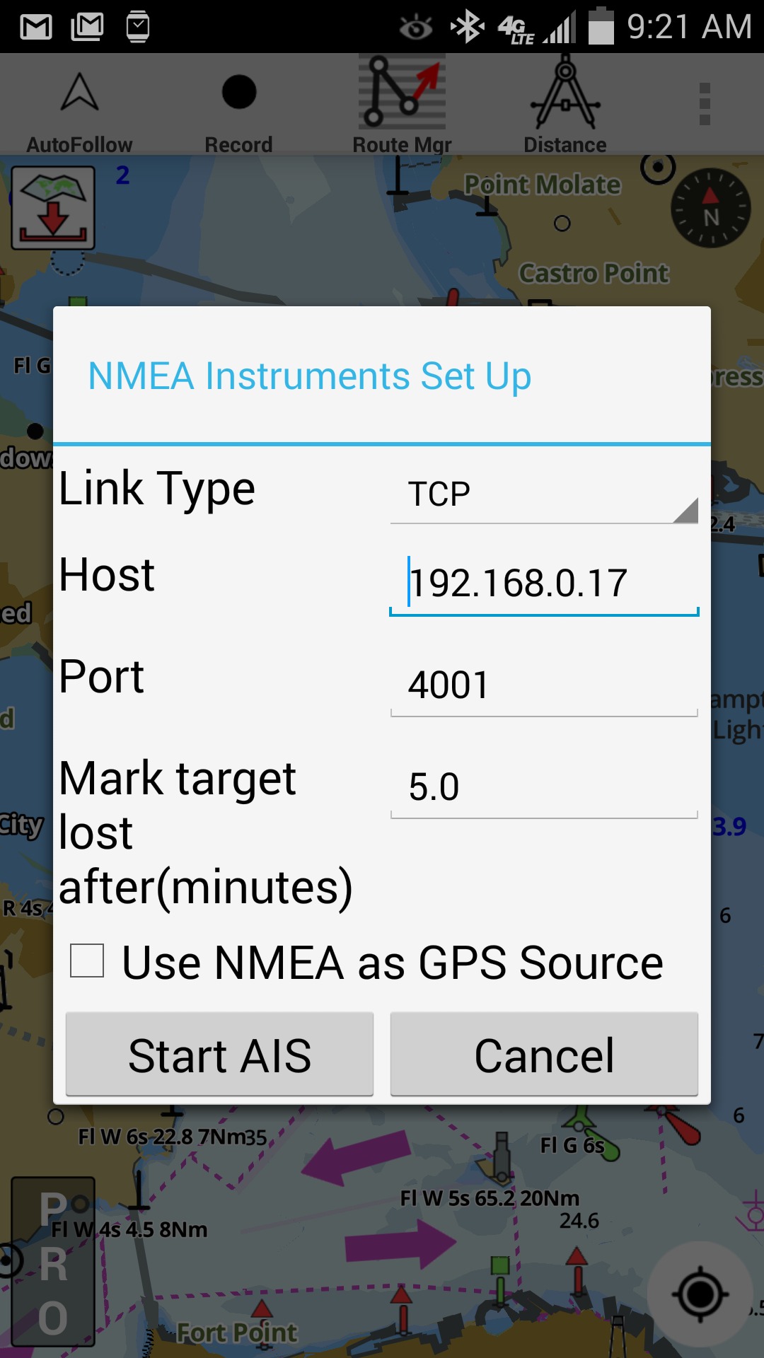
- Press menu/overflow button and select "Start AIS" and enter the following details:
You would have to refer to your AIS receiver manual to get the exact values. The application supports NMEA over both TCP & UDP.
Using Linktype TCP
When connecting to NMEA source over TCP, you must supply the host address and the port number to which the app should connect. Plese refer to your instruments manual to get the IP address and port number.
- Host Address: This is the IP address the app would connect.
- TCP Port
Using Linktype UDP
The application supports NMEA source that sends data over UDP (including broadcast) as well. In this case you only need to enter the port number in the app.
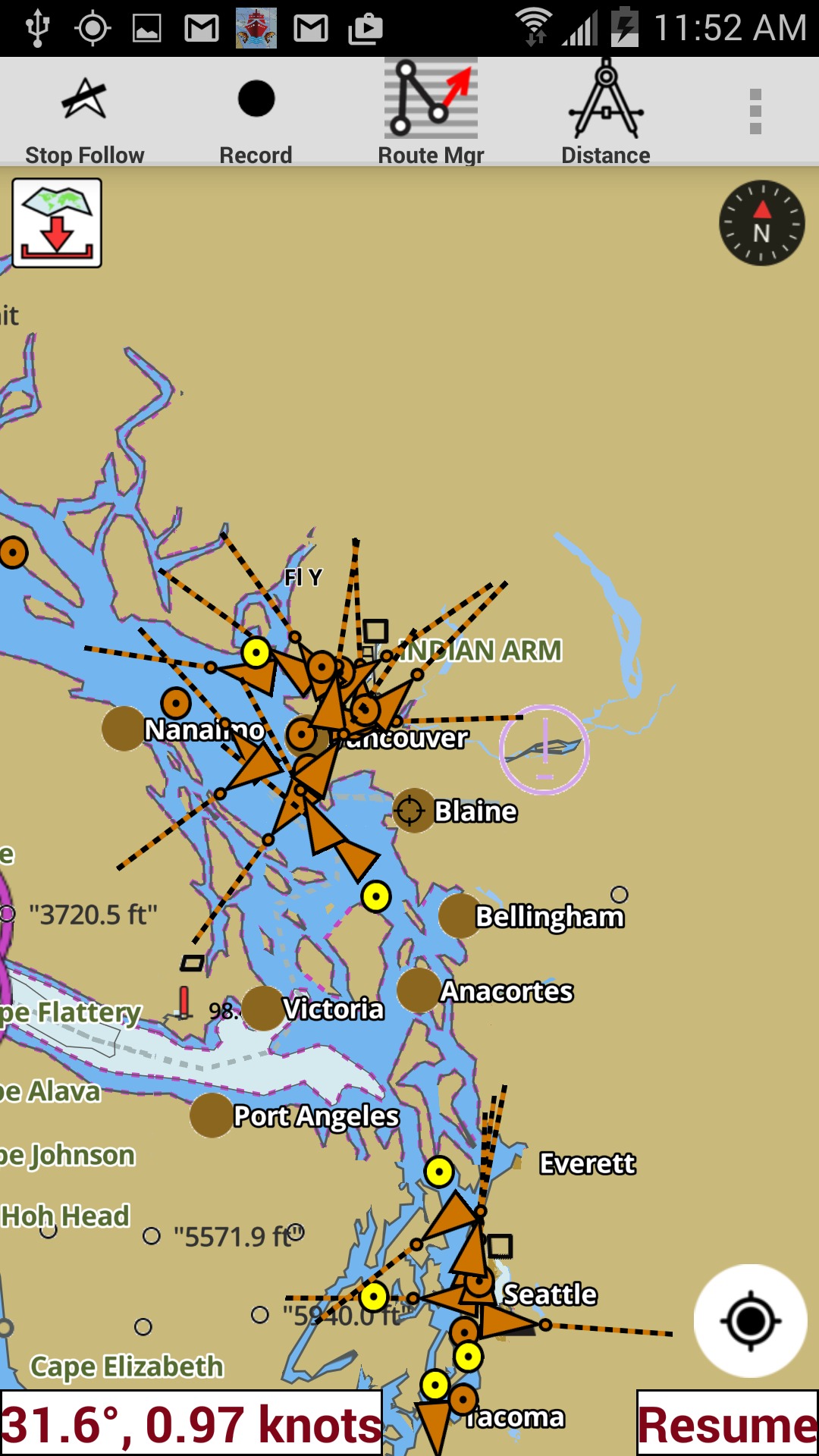
AIS display in i-Boating app
- The app support automatic age-ing of targets. The targets would turn grey if no mesages are received for that target for 5 minutes. You can adjust this interval in AIS setup when you start AIS.
- The targets are color coded. Class A Targets are orange, Class B targets are dark pink, Base station targets are green, ATONs are purple, SART are red and everything else is yellow.
- If the heading is available, then the target is drawn with the heading vector drawn on the map.
- Tapping on a target would display all info about the target (including static info such as name, ETA, destinatin, MMSI etc.).
- Static AIS messages are sent less frequently than dynamic AIS messages. So static info about a target make take a little longer to become available.
Using GPS over NMEA
There are several AIS receivers that can stream GPS data as NMEA over TCP/UDP (on wifi network setup by that receiver). There are several Windows and Mac applications that can do the same. You can force the i-Boating client to use this as GPS source instead of the built in GPS receiver on your android device.
Please use the following steps to enable GPS over NMEA.
- Tap menu/overflow button and select Settings
- In Setting screen scroll down and tap on "NMEA Instrument Settings"
- Check the box " Use NMEA as GPS Source"
- Tap on Save
Please note that this will change GPS source for all features in the app (including Auto Follow, Track Recording, Route Assistance, Waypoints using current location etc.). The app will not use built in GPS receiver. Instead it will always try to use GPS data from the NMEA source.
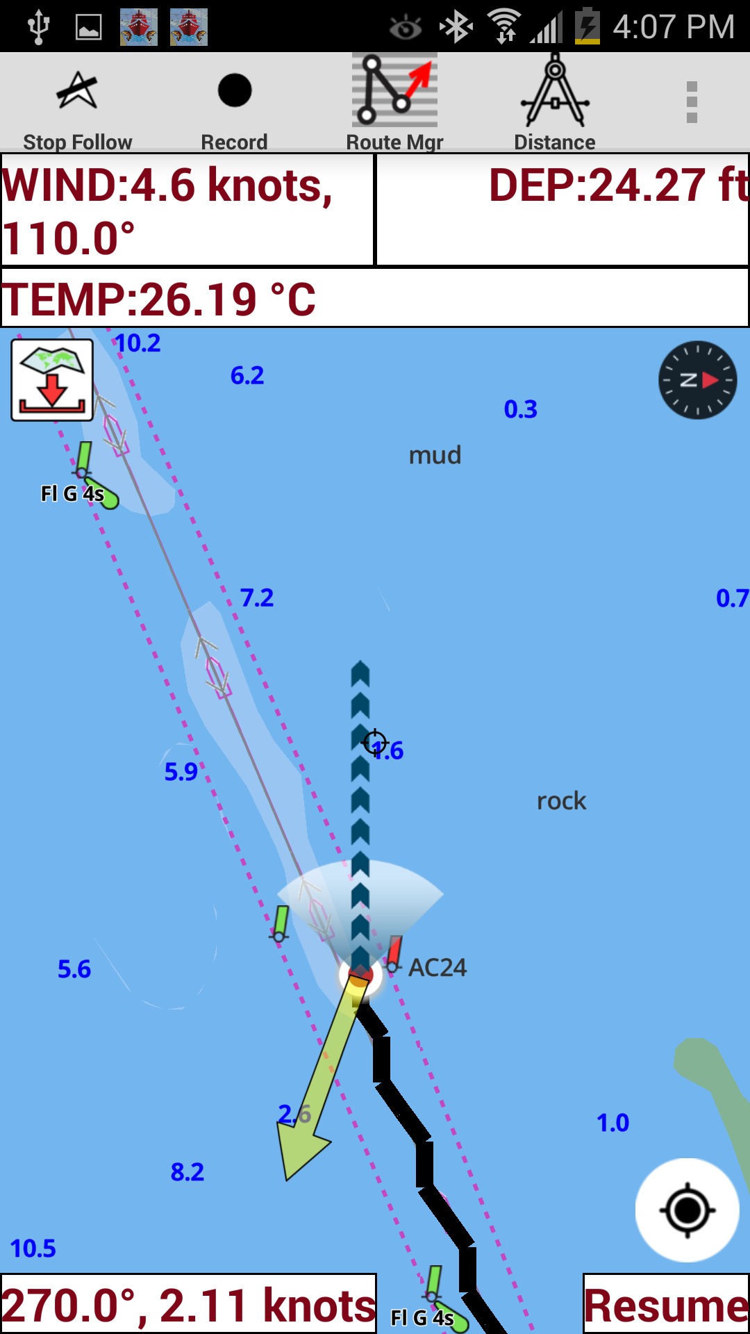
Wind, Sonar, Temperature and other instruments data
The application includes support for NMEA instruments.
- Wind direction: The application also shows the wind direction as yellow arrow next to the current location. To view wind direction on the map, you must tap on Auto Follow. Otherwise it is just shows as text on top of the map.
- Wind speed
- Sonar depth
- Water temperature
Based on our customer's feedback, we have added support of the above data to show on the map. If you would like to view other instrument data, please contact us with more details.
Supported AIS Receivers/Instruments
- The application supports NMEA sources that can stream NMEA over TCP/UDP on the network to which the device is connected. There are self-contained devices which can set up their own network. There are applications available for windows and Mac, which can set up an NMEA source as well. i-Boating should work in all these configurations.
- AIS is supported over TCP and UDP (NMEA over TCP/UDP). Please check maual of your AIS receiver on setting up the network to which external devices can connect over wifi.
NMEA over TCP vs NMEA over UDP
- The application supports NMEA over both TCP and UDP. So, if you already have a working setup for your instruments, it should work out of the box in i-Boating.
- If you are setting up your instruments from scratch, we recommend setting up to stream over TCP.
- TCP is a connection-oriented, reliable transfer network protocol. This allows applications like i-Boating to give more robust, accurate error messages.
- UDP is a connection less, un-reliable transfer network protocol.
Auto Pilot Support
When using "Route Assistance" or "Goto WayPoint" in i-Boating, the application can now send AutoPilot NMEA commands to your Auto Pilot over TCP. You can configure the talker ID and the set of NMEA commands under Settings.
Verified NMEA wifi routers, wind sensors & instruments
The i-Boating app for Android has been verified to work with the instruments manufactured by the following companies:
- vYacht: NMEA router manufactured by router is verified with the i-Boating app for Android. By default data is translated to NMEA 0183 and send to the NMEA 0183 output and via wifi/ethernet.
- NaWifi: Wifi Anemometers, developed by NaWifi have been verified with the i-Boating app as well.