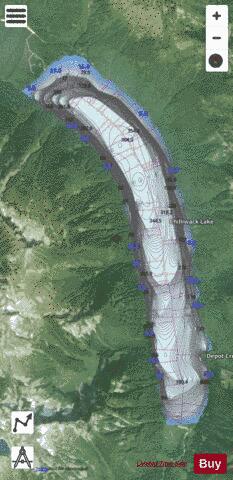
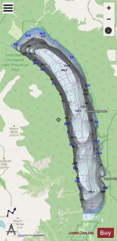
Chilliwack Lake fishing map is included in Lakes and Rivers of British Columbia nautical charts folio. It is available as part of iBoating : Canada Marine & Fishing App (now supported on multiple platforms including Android, iPhone/iPad, MacBook, and Windows(tablet and phone)/PC based chartplotter. ).
With our Lake Maps App, you get all the great marine chart app features like fishing spots, along with Chilliwack Lake depth map. The fishing maps app include HD lake depth contours, along with advanced features found in Fish Finder / Gps Chart Plotter systems, turning your device into a Depth Finder. The Chilliwack Lake Navigation App provides advanced features of a Marine Chartplotter including adjusting water level offset and custom depth shading. Fishing spots and depth contours layers are available in most Lake maps. Lake navigation features include advanced instrumentation to gather wind speed direction, water temperature, water depth, and accurate GPS with AIS receivers(using NMEA over TCP/UDP). Autopilot support can be enabled during ‘Goto WayPoint’ and ‘Route Assistance’.
Now i-Boating supports Fishing Points in Chilliwack Lake.
Have more questions about the Nautical Chart App? Ask us.
Fishing Info for Chilliwack Lake
Chilliwack Lake is a lake in the upper basin of the Chilliwack River southeast of the city of the same name in the Lower Mainland of British Columbia, Canada. The lake, while entirely within Canada, is located just north of the border between British Columbia and the state of Washington and is both fed and drained by the Chilliwack River, which has its source in the North Cascades of Washington state and Canada, which surround the lake on all sides.
More on Wikipedia...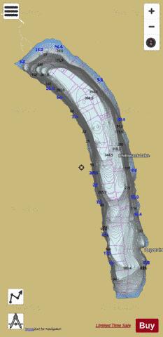
Chilliwack Lake Fishing Map Stats | |
| Title | Chilliwack Lake |
| Scale | 1:24000 |
| Districts | Fraser Valley |
| Nearby Cities | Hope, Rosedale, Kent, Harrison Hot Springs, Cultus Lake, Chilliwack, Mission, Abbotsford, Princeton, Aldergrove East |
| Area * | 2917.32 acres |
| Shoreline * | 13.31 miles |
| Min Longitude | -121.46 |
| Min Latitude | 49.02 |
| Max Longitude | -121.40 |
| Max Latitude | 49.09 |
| Edition Label 1 | |
| Edition Label 2 | |
| Edition Label 3 | |
| Id | CA_BC_chilliwack_lake_bc |
| Country | CA |
| Projection | Mercator |
| * some Stats may include nearby/connecting waterbodies | |
|