Takla Lake fishing map is included in Lakes and Rivers of British Columbia nautical charts folio. It is available as part of iBoating : Canada Marine & Fishing App (now supported on multiple platforms including Android, iPhone/iPad, MacBook, and Windows(tablet and phone)/PC based chartplotter. ).
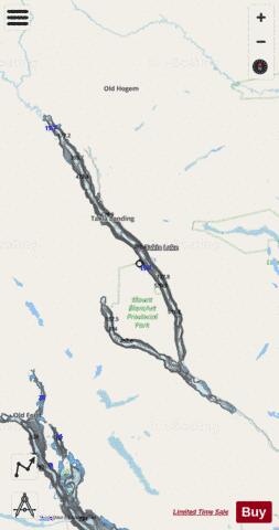
With our Lake Maps App, you get all the great marine chart app features like fishing spots, along with Takla Lake depth map. The fishing maps app include HD lake depth contours, along with advanced features found in Fish Finder / Gps Chart Plotter systems, turning your device into a Depth Finder. The Takla Lake Navigation App provides advanced features of a Marine Chartplotter including adjusting water level offset and custom depth shading. Fishing spots and depth contours layers are available in most Lake maps. Lake navigation features include advanced instrumentation to gather wind speed direction, water temperature, water depth, and accurate GPS with AIS receivers(using NMEA over TCP/UDP). Autopilot support can be enabled during ‘Goto WayPoint’ and ‘Route Assistance’.
Now i-Boating supports Fishing Points in Takla Lake.
Have more questions about the Nautical Chart App? Ask us.
Fishing Info for Takla Lake
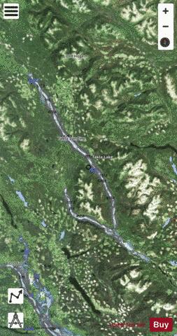
Takla Lake is the fifth largest natural lake in British Columbia, Canada. It is a deep fjord-like lake with the Swannell Ranges to the east, the flowing into it from the north, and the Middle River draining it. It is the terminus of the early Stuart-Takla sockeye salmon run, and noted for its large rainbow trout, lake trout and Dolly Varden. The peninsula is the home of Mount Blanchet Provincial Park. Also on the peninsula is a herd of collared woodland caribou, and the winter range of grizzly bears. Two special features are Takla Lake Marine Park, and an Ecological Reserve on the peninsula, a stand of very northerly Douglas Fir. Takla Lake is also the origin of both of Canada's national airlines, both Russ Baker and Grant McConachie running bush plane routes out of Takla Lake. It is a popular canoe route from the top end down to Fort St. James. Takla Lake may be a corruption of thaitla, meaning "bottom of the lake" (18th Annual Report, G.B.C).
More on Wikipedia...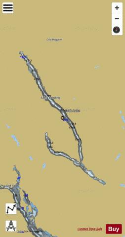
Takla Lake Fishing Map Stats | |
| Title | Takla Lake |
| Scale | 1:24000 |
| Districts | Bulkley-Nechako |
| Nearby Cities | Burns Lake |
| Area * | 61059.13 acres |
| Shoreline * | 173.07 miles |
| Min Longitude | -126.25 |
| Min Latitude | 55.05 |
| Max Longitude | -125.51 |
| Max Latitude | 55.71 |
| Edition Label 1 | |
| Edition Label 2 | |
| Edition Label 3 | |
| Id | CA_BC_takla_lake_bc |
| Country | CA |
| Projection | Mercator |
| * some Stats may include nearby/connecting waterbodies | |
|