Shebandowan Lakes fishing map is included in Ontario Lakes nautical charts folio. It is available as part of iBoating : Canada Marine & Fishing App (now supported on multiple platforms including Android, iPhone/iPad, MacBook, and Windows(tablet and phone)/PC based chartplotter. ).
With our Lake Maps App, you get all the great marine chart app features like fishing spots, along with Shebandowan Lakes lake depth map. The fishing maps app include HD lake depth contours, along with advanced features found in Fish Finder / Gps Chart Plotter systems, turning your device into a Depth Finder. The Shebandowan Lakes Navigation App provides advanced features of a Marine Chartplotter including adjusting water level offset and custom depth shading. Fishing spots and depth contours layers are available in most Lake maps. Lake navigation features include advanced instrumentation to gather wind speed direction, water temperature, water depth, and accurate GPS with AIS receivers(using NMEA over TCP/UDP). Autopilot support can be enabled during ‘Goto WayPoint’ and ‘Route Assistance’.
Now i-Boating supports Fishing Points in Shebandowan Lakes.
Have more questions about the Nautical Chart App? Ask us.
Fishing Info for Shebandowan Lakes
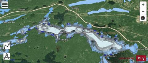
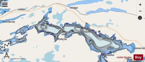
Shebandowan Lakes is the name for the combined entity of three lakes — Upper Shebandowan Lake at the west, Middle Shebandowan Lake at the centre, and Lower Shebandowan Lake at the east — in the Unorganized Part of Thunder Bay District in Northwestern Ontario, Canada. The lakes are in the Great Lakes Basin, and Lower Shebandowan Lake is the source of the Shebandowan River. The primary inflows are Greenwater Creek at the southwest; the Kashabowie River at the north; and the Swamp River at the northeast. The primary outflow is the Shebandowan River, which leaves Lower Shebandowan Lake over a weir at the east at the community of Shebandowan, and flows via the Matawin River and the Kaministiquia River to Lake Superior. Ontario Highway 11, at this point part of the Trans-Canada Highway, follows the north shore of the lakes. Ontario Highway 586 branches from Highway 11 along an isthmus between Middle Shebandowan Lake and Lower Shebandowan Lake. The Canadian National Railway Kashabowie Subdivision main line, built originally as the Canadian Northern Railway transcontinental main line, also follows the north shore of the lakes. Kashabowie/Upper Shebandowan Lake Water Aerodrome is on Upper Shebandowan Lake.
More on Wikipedia...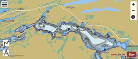
Shebandowan Lakes Fishing Map Stats | |
| Title | Shebandowan Lakes |
| Scale | 1:24000 |
| Districts | Thunder Bay |
| Nearby Cities | Thunder Bay |
| Area * | 4448.30 acres |
| Shoreline * | 41.06 miles |
| Min Longitude | -90.37 |
| Min Latitude | 48.62 |
| Max Longitude | -90.18 |
| Max Latitude | 48.67 |
| Edition Label 1 | |
| Edition Label 2 | |
| Edition Label 3 | |
| Id | CA_ON_V_103382588 |
| Country | CA |
| Projection | Mercator |
| * some Stats may include nearby/connecting waterbodies | |
| ||||||||||||||||||||||||||||||||||||||||||||||||||||||||||||||||||||||||||||||||||||||||||||||||||||||||
|