Lochinvar (Dee Basin) fishing map is included in Scotland - Dumfries and Galloway Lochs nautical charts folio. It is available as part of iBoating : Inland Europe Marine & Fishing App (now supported on multiple platforms including Android, iPhone/iPad, MacBook, and Windows(tablet and phone)/PC based chartplotter. ).
With our Lake Maps App, you get all the great marine chart app features like fishing spots, along with Lochinvar (Dee Basin) lake depth map. The fishing maps app include HD lake depth contours, along with advanced features found in Fish Finder / Gps Chart Plotter systems, turning your device into a Depth Finder. The Lochinvar (Dee Basin) Navigation App provides advanced features of a Marine Chartplotter including adjusting water level offset and custom depth shading. Fishing spots and depth contours layers are available in most Lake maps. Lake navigation features include advanced instrumentation to gather wind speed direction, water temperature, water depth, and accurate GPS with AIS receivers(using NMEA over TCP/UDP). Autopilot support can be enabled during ‘Goto WayPoint’ and ‘Route Assistance’.
Have more questions about the Nautical Chart App? Ask us.
Fishing Info for Lochinvar (Dee Basin)
Lochinvar (or Lan Var) is a loch in the civil parish of Dalry in the historic county of Kirkcudbrightshire, Dumfries and Galloway Scotland. It is located in the Galloway Hills, around 3.5 miles (5.6 km) north-east of St. John's Town of Dalry. The loch formerly had an island on which stood Lochinvar Castle, seat of the Gordon family. In the 20th century the loch was dammed to form a reservoir, raising the water level and submerging the island with the ruins of the castle. The loch is used for trout fishing. The name Lochinvar is from Scots Gaelic Loch a' bharra (older Gaelic Loch an bharra, the genitive of barr = summit) meaning "Loch on the hilltop". Consequently it is stressed on the last syllable (unlike Lochinver).
More on Wikipedia...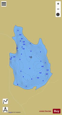
Lochinvar (Dee Basin) Fishing Map Stats | |
| Title | Lochinvar (Dee Basin) |
| Scale | 1:6000 |
| Area * | 79.95 acres |
| Shoreline * | 1.78 miles |
| Min Longitude | -4.11 |
| Min Latitude | 55.14 |
| Max Longitude | -4.10 |
| Max Latitude | 55.15 |
| Edition Label 1 | |
| Edition Label 2 | |
| Edition Label 3 | |
| Id | II_SCOT_74400508_5_scot |
| Country | Inland Europe |
| Projection | Mercator |
| * some Stats may include nearby/connecting waterbodies | |
| |||||||||||||||||||||||||||||||||||||||||||||||||||||||||||||||||||||||||||||||||||||||||||||||||||||||
|