Loch Calder (Forss Basin) fishing map is included in Scotland - Highland Lochs nautical charts folio. It is available as part of iBoating : Inland Europe Marine & Fishing App (now supported on multiple platforms including Android, iPhone/iPad, MacBook, and Windows(tablet and phone)/PC based chartplotter. ).
With our Lake Maps App, you get all the great marine chart app features like fishing spots, along with Loch Calder (Forss Basin) lake depth map. The fishing maps app include HD lake depth contours, along with advanced features found in Fish Finder / Gps Chart Plotter systems, turning your device into a Depth Finder. The Loch Calder (Forss Basin) Navigation App provides advanced features of a Marine Chartplotter including adjusting water level offset and custom depth shading. Fishing spots and depth contours layers are available in most Lake maps. Lake navigation features include advanced instrumentation to gather wind speed direction, water temperature, water depth, and accurate GPS with AIS receivers(using NMEA over TCP/UDP). Autopilot support can be enabled during ‘Goto WayPoint’ and ‘Route Assistance’.
Have more questions about the Nautical Chart App? Ask us.
Fishing Info for Loch Calder (Forss Basin)
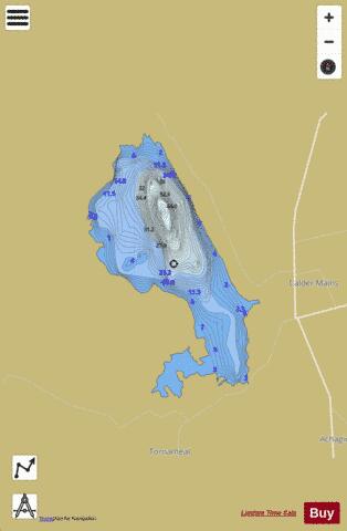
Loch Calder is a lowland freshwater loch lying approximately 5 mi (8.0 km) south west of Thurso in the Scottish Highlands. The loch is large with an irregular shape and has perimeter of 12.8 km (8.0 mi). It is approximately 2.33 mi (3.75 km) long, has an average depth of 21 ft (6.4 m) and is 85 ft (26 m) at its deepest. The loch was surveyed on 6 October 1902 by John Parsons and T.R.H. Garrett and later charted as part of Sir John Murray's Bathymetrical Survey of Fresh-Water Lochs of Scotland 1897-1909. Around the loch are several archaeological remains. At the northern end of the loch is Tulach an t'Sionnaich, a well preserved chambered cairn, one of two cairns known as the . On the eastern shore, near Achavarn, lies the site of a broch, although much of the structure has been removed. It is thought that there was an artificial island or crannog near the western shore dating from the 17th century. The island, known as Big Island, may have contained a dwelling which was said to be that of a robber. A short distance to the west of the loch is a ruined stone circle. Several of the stones remain, five of which are upright with the largest being 1.3 m (4 ft 3 in) high. The loch is a Scottish Natural Heritage Site of Special Scientific Interest for its Greenland white-fronted goose, Greylag goose and Whooper swans. The loch is popular for fishing and contains trout, Arctic char and ferox trout.
More on Wikipedia...Popular fish species in this lake include Arctic char.
Loch Calder (Forss Basin) Fishing Map Stats | |
| Title | Loch Calder (Forss Basin) |
| Scale | 1:12000 |
| Area * | 1050.03 acres |
| Shoreline * | 9.66 miles |
| Min Longitude | -3.62 |
| Min Latitude | 58.50 |
| Max Longitude | -3.57 |
| Max Latitude | 58.54 |
| Edition Label 1 | |
| Edition Label 2 | |
| Edition Label 3 | |
| Id | II_SCOT_74422297_0_scot |
| Country | Inland Europe |
| Projection | Mercator |
| * some Stats may include nearby/connecting waterbodies | |
| |||||||||||||||||||||||||||||||||||||||||||||||||||||||||||||||||||||||||||||||||||||||||||||||||||||||
|