LAKE HARRIS fishing map is available as part of iBoating : USA Marine & Fishing App(now supported on multiple platforms including Android, iPhone/iPad, MacBook, and Windows(tablet and phone)/PC based chartplotter.).
With our Lake Maps App, you get all the great marine chart app features like fishing spots, along with LAKE HARRIS depth map. The fishing maps app include HD lake depth contours, along with advanced features found in Fish Finder / Gps Chart Plotter systems, turning your device into a Depth Finder. The LAKE HARRIS Navigation App provides advanced features of a Marine Chartplotter including adjusting water level offset and custom depth shading. Fishing spots and depth contours layers are available in most Lake maps. Lake navigation features include advanced instrumentation to gather wind speed direction, water temperature, water depth, and accurate GPS with AIS receivers(using NMEA over TCP/UDP). Autopilot support can be enabled during ‘Goto WayPoint’ and ‘Route Assistance’.
Now i-Boating supports Fishing Points in LAKE HARRIS.
Have more questions about the Nautical Chart App? Ask us.
Fishing Info for LAKE HARRIS
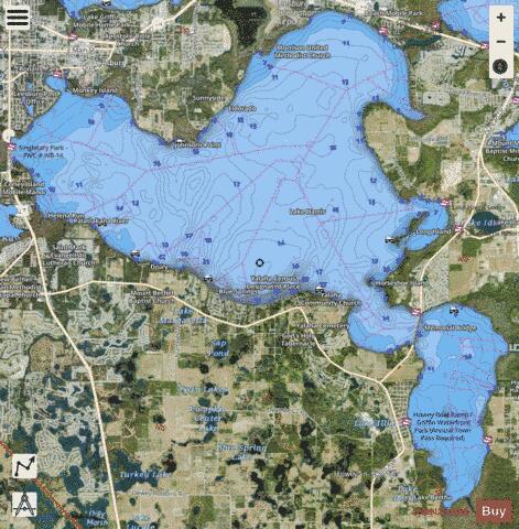
Lake Harris is a lake in Lake County, Florida, United States, 31 miles (50 km) northwest of Orlando. It is part of the Upper Ocklawaha River Basin, a sub-watershed of the St. Johns River. It is one of seven lakes in the Harris Chain of Lakes or "Ocklawaha Chain of Lakes". Lake Harris is the largest lake entirely in Lake County, at 13,788 acres (56 km2), with an irregular shape when viewed from the air. An adjoining bay, Little Lake Harris, east of SR 19, is a smaller version of the lake. The combined area of the two lakes exceeds 15,000 acres (61 km2). The lake's northeastern shore is a landing approach zone for Leesburg International Airport. It is a harbor city for Leesburg, at the northwestern shore of the lake. At the westernmost point of the lake is U.S. Route 27/SR 25. Lake Harris' primary inflow is at its southwestern shore from the Palatlakaha River, which originates from the Clermont chain of lakes to the south. Other inflowing rivers include Helena Run, and outflow from many small springs in Yalaha. Lake Harris' depth is much greater than Lake Okeechobee to the south, with many deeper holes and ledges. The lake is surrounded by sandhills and cypress trees, part of the Central Florida Ridge. This region has the highest elevations in central Florida, including Sugarloaf Mountain reaching 312 feet (95 m) above sea level. Compared to the rest of Florida, which is relatively flat, it is quite hilly. There are three public launching ramps on Lake Harris; off U.S. Route 27 to the west, Venetian Gardens in Leesburg, and Hickory Point near the Howey-in-the-Hills bridge off SR 19. There is a small but serviceable ramp on the east side of Little Lake Harris in the town of Astatula. The lake is ringed with cattail and bullrush, except for the occasional boat, dock, or seawall. The depth in these tall grasses normally ranges from 2 to 5 feet (0.61 to 1.52 m). The bottom is mostly hard sand, except for some marshy areas where the bottom is considerably softer. These sheltered areas around the edge can offer a good place to fish during inclement weather.
More on Wikipedia...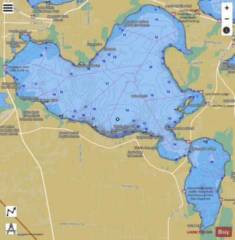
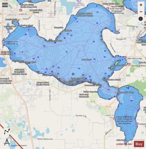
LAKE HARRIS Fishing Map Stats | |
| Title | LAKE HARRIS |
| Scale | 1:12000 |
| 1 ft Depth Contours for Anglers | Yes |
| Counties | Lake |
| Nearby Cities | Howey-in-the-Hills, Leesburg, Hawthorne, Yalaha, Sunnyside, Astatula, Bassville Park, Okahumpka, Tavares, Fruitland Park |
| Area * | 18415.87 acres |
| Shoreline * | 52.11 miles |
| Min Longitude | -81.89 |
| Min Latitude | 28.69 |
| Max Longitude | -81.74 |
| Max Latitude | 28.82 |
| Edition Label 1 | |
| Edition Label 2 | |
| Edition Label 3 | |
| Id | US_FL_00294031 |
| Country | US |
| Projection | Mercator |
| * some Stats may include nearby/connecting waterbodies | |
|