Anahuac fishing map is available as part of iBoating : USA Marine & Fishing App(now supported on multiple platforms including Android, iPhone/iPad, MacBook, and Windows(tablet and phone)/PC based chartplotter.).
With our Lake Maps App, you get all the great marine chart app features like fishing spots, along with Anahuac lake depth map. The fishing maps app include HD lake depth contours, along with advanced features found in Fish Finder / Gps Chart Plotter systems, turning your device into a Depth Finder. The Anahuac Navigation App provides advanced features of a Marine Chartplotter including adjusting water level offset and custom depth shading. Fishing spots and depth contours layers are available in most Lake maps. Lake navigation features include advanced instrumentation to gather wind speed direction, water temperature, water depth, and accurate GPS with AIS receivers(using NMEA over TCP/UDP). Autopilot support can be enabled during ‘Goto WayPoint’ and ‘Route Assistance’.
Have more questions about the Nautical Chart App? Ask us.
Fishing Info for Anahuac
Lake Anahuac is an artificial lake fed by the Trinity River, 45 miles (72 km) east of downtown Houston, Texas, United States in western Chambers County. The city of Anahuac lies on its eastern shores. It was constructed by the Burkhalter family in 1953. The lake was once Turtle Bay until the mouth of the bay was closed in the early 1900s. The current dam and levee system was completed in 1954.
More on Wikipedia...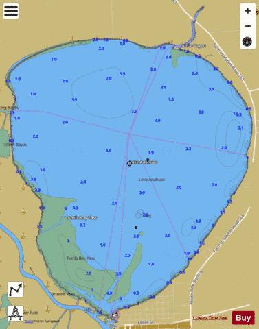
Anahuac Fishing Map Stats | |
| Title | Anahuac |
| Scale | 1:24000 |
| Counties | Chambers |
| Nearby Cities | Anahuac, Hankamer, Monroe City, Cove, Double Bayou, Oak Island, Old River-Winfree, Mont Belvieu, Devers, Beach City |
| Area * | 5035.72 acres |
| Shoreline * | 13.16 miles |
| Min Longitude | -94.71 |
| Min Latitude | 29.77 |
| Max Longitude | -94.66 |
| Max Latitude | 29.83 |
| Edition Label 1 | |
| Edition Label 2 | |
| Edition Label 3 | |
| Id | US_TX_anahuac |
| Country | US |
| Projection | Mercator |
| * some Stats may include nearby/connecting waterbodies | |
|