LAKE WIMAUMA fishing map is available as part of iBoating : USA Marine & Fishing App(now supported on multiple platforms including Android, iPhone/iPad, MacBook, and Windows(tablet and phone)/PC based chartplotter.).
With our Lake Maps App, you get all the great marine chart app features like fishing spots, along with LAKE WIMAUMA depth map. The fishing maps app include HD lake depth contours, along with advanced features found in Fish Finder / Gps Chart Plotter systems, turning your device into a Depth Finder. The LAKE WIMAUMA Navigation App provides advanced features of a Marine Chartplotter including adjusting water level offset and custom depth shading. Fishing spots and depth contours layers are available in most Lake maps. Lake navigation features include advanced instrumentation to gather wind speed direction, water temperature, water depth, and accurate GPS with AIS receivers(using NMEA over TCP/UDP). Autopilot support can be enabled during ‘Goto WayPoint’ and ‘Route Assistance’.
Now i-Boating supports Fishing Points in LAKE WIMAUMA.
Have more questions about the Nautical Chart App? Ask us.
Fishing Info for LAKE WIMAUMA
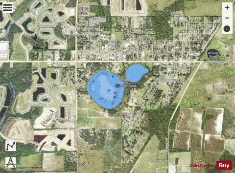
Lake Wimauma, on the south side of the town of Wimauma, Florida, could be considered two lakes, basically round in shape. When the water level is high, they are connected by a short narrow channel. The south part of the lake is much larger than the northern part. Lake Wimauma has a 108-acre (440,000 m2) surface area. To the north of the northern part is Florida State Route 674. The entire lake is surrounded by trees, grassland and a scattering of residences. Although the lake is in a rural area, Hillsborough County, Florida, is the home of Tampa, Florida. There are no public boat ramps or swimming beaches on the lake's shores, but along SR 674, on the north part of the lake, is an area where cars may pull off the road and where the lake can be accessed by the public. The Hook and Bullet website says the lake contains largemouth bass, bluegill and crappie.
More on Wikipedia...Popular fish species in this lake include Crappie and Largemouth bass.
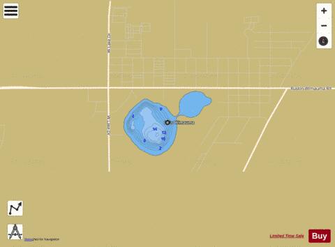
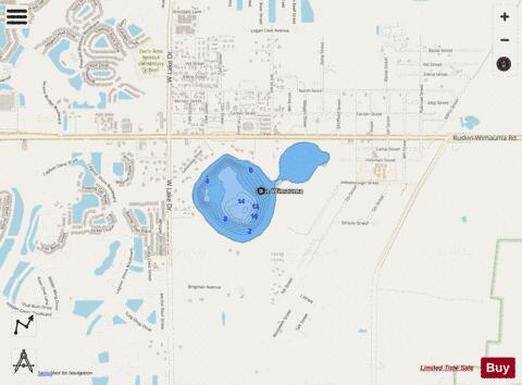
LAKE WIMAUMA Fishing Map Stats | |
| Title | LAKE WIMAUMA |
| Scale | 1:3000 |
| 1 ft Depth Contours for Anglers | Yes |
| Counties | Hillsborough |
| Nearby Cities | Wimauma, Sun City Center, Balm, Apollo Beach, Ruskin, Riverview, Gibsonton, Parrish, Sun City, Bloomingdale |
| Area * | 107.66 acres |
| Shoreline * | 2.11 miles |
| Min Longitude | -82.32 |
| Min Latitude | 27.70 |
| Max Longitude | -82.31 |
| Max Latitude | 27.71 |
| Edition Label 1 | |
| Edition Label 2 | |
| Edition Label 3 | |
| Id | US_FL_00293392 |
| Country | US |
| Projection | Mercator |
| * some Stats may include nearby/connecting waterbodies | |
|