Manistique Lake fishing map is available as part of iBoating : USA Marine & Fishing App(now supported on multiple platforms including Android, iPhone/iPad, MacBook, and Windows(tablet and phone)/PC based chartplotter.).
With our Lake Maps App, you get all the great marine chart app features like fishing spots, along with Manistique Lake depth map. The fishing maps app include HD lake depth contours, along with advanced features found in Fish Finder / Gps Chart Plotter systems, turning your device into a Depth Finder. The Manistique Lake Navigation App provides advanced features of a Marine Chartplotter including adjusting water level offset and custom depth shading. Fishing spots and depth contours layers are available in most Lake maps. Lake navigation features include advanced instrumentation to gather wind speed direction, water temperature, water depth, and accurate GPS with AIS receivers(using NMEA over TCP/UDP). Autopilot support can be enabled during ‘Goto WayPoint’ and ‘Route Assistance’.
Now i-Boating supports Fishing Points in Manistique Lake.
Have more questions about the Nautical Chart App? Ask us.
Fishing Info for Manistique Lake
Manistique Lake, locally called Big Manistique Lake to distinguish it from the other lakes in the Manistique Lakes system, is a 10,130-acre (4,100 ha) lake in the Upper Peninsula of the U.S. state of Michigan. Approximately 6.5 miles (10.5 km) long and 4 miles (6.4 km) wide, it is one of the largest lakes in the Upper Peninsula. Elevated 686 feet (209 m) above sea level and 105 feet (32 m) above Lake Michigan, Manistique Lake drains into the larger lake through a marshy outlet on the west end of the lake that forms one source of the Manistique River. Relatively shallow, the lake's deepest point is only 20 feet (6.1 m) below the water surface. The average depth is 10 feet (3.0 m). The lake is shared between Luce County and Mackinac County. The small town of Curtis, Michigan is located on an isthmus that divides Manistique Lake from South Manistique Lake directly to the south. Manistique Lake has at least three islands large enough to show up on maps - Burnt Island near the eastern shore, Foster Island near the northern shore, and Greenfield Island near the center of the lake. Many seasonal residents use Manistique Lake as a focus of summer recreational activity. The relatively shallow lake is favored for swimming, powerboating, personal watercraft, fishing, ice fishing, and camping. The Michigan Department of Natural Resources (MDNR) recommends the lake for fishing and boating. Fish caught in the lake include bluegill, largemouth bass, muskie, perch, northern pike, rock bass, smallmouth bass, sunfish, and walleye.
More on Wikipedia...Popular fish species in this lake include Largemouth bass, Lepomis, Northern pike, Rock bass, Smallmouth bass and Walleye.
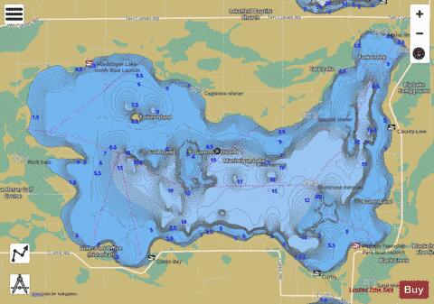
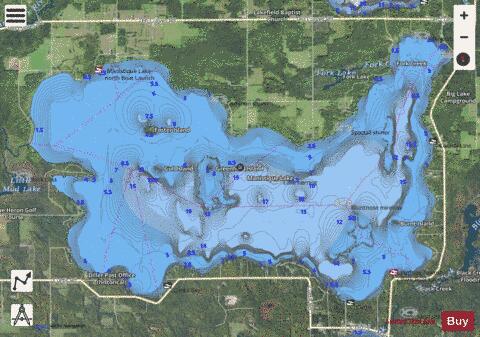
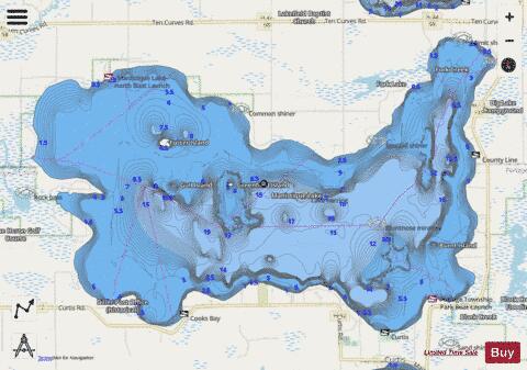
Manistique Lake Fishing Map Stats | |
| Title | Manistique Lake |
| Scale | 1:24000 |
| Includes Data from Fish Atlas | Yes |
| Counties | Luce, Mackinac |
| Nearby Cities | Germfask, McMillan, Gould City, Seney, Engadine, Newberry, Naubinway, Grand Marais, Rexton, Manistique |
| Area * | 10353.55 acres |
| Shoreline * | 25.15 miles |
| Min Longitude | -85.85 |
| Min Latitude | 46.21 |
| Max Longitude | -85.72 |
| Max Latitude | 46.27 |
| Edition Label 1 | |
| Edition Label 2 | |
| Edition Label 3 | |
| Id | US_MI_48_53 |
| Country | US |
| Projection | Mercator |
| * some Stats may include nearby/connecting waterbodies | |
|