Minnetonka fishing map is available as part of iBoating : USA Marine & Fishing App(now supported on multiple platforms including Android, iPhone/iPad, MacBook, and Windows(tablet and phone)/PC based chartplotter.).
With our Lake Maps App, you get all the great marine chart app features like fishing spots, along with Minnetonka lake depth map. The fishing maps app include HD lake depth contours, along with advanced features found in Fish Finder / Gps Chart Plotter systems, turning your device into a Depth Finder. The Minnetonka Navigation App provides advanced features of a Marine Chartplotter including adjusting water level offset and custom depth shading. Fishing spots and depth contours layers are available in most Lake maps. Lake navigation features include advanced instrumentation to gather wind speed direction, water temperature, water depth, and accurate GPS with AIS receivers(using NMEA over TCP/UDP). Autopilot support can be enabled during ‘Goto WayPoint’ and ‘Route Assistance’.
Now i-Boating supports Fishing Points in Minnetonka.
Have more questions about the Nautical Chart App? Ask us.
Fishing Info for Minnetonka
Lake Minnetonka (Dakota: Mní iá Tháŋka) is a lake located approximately 15 miles (24 km) west-southwest of Minneapolis, Minnesota. Lake Minnetonka has about 23 named bays and areas. The lake lies within Hennepin and Carver counties and is surrounded by 13 incorporated municipalities. At 14,528 acres (5,879 ha), it is Minnesota's ninth largest lake. It is a popular spot for local boaters, sailors, and fishermen.
More on Wikipedia...Popular fish species in this lake include Black bullhead, Black crappie, Bowfin, Common carp, Green sunfish, Largemouth bass, Northern pike, Pumpkinseed, Rock bass, Smallmouth bass, Walleye, White sucker, Yellow bullhead and Yellow perch.
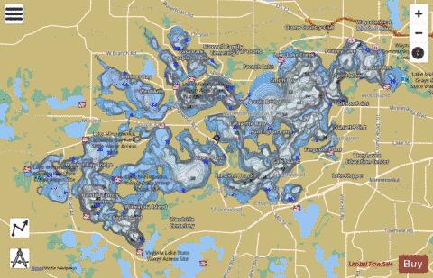


Minnetonka Fishing Map Stats | |
| Title | Minnetonka |
| Sailing Clubs in this Chart region | |
| Minnetonka Yacht Club | |
| Shorewood Yacht Club | |
| Upper Minnetonka Yacht Club | |
| Wayzata Yacht Club | |
| Scale | 1:24000 |
| Counties | Carver, Hennepin |
| Nearby Cities | Minnetonka Beach, Greenwood, Spring Park, Excelsior, Tonka Bay, Deephaven, Woodland, Shorewood, Orono, Mound |
| Area * | 14216.18 acres |
| Shoreline * | 133.34 miles |
| Min Longitude | -93.70 |
| Min Latitude | 44.88 |
| Max Longitude | -93.49 |
| Max Latitude | 44.97 |
| Edition Label 1 | |
| Edition Label 2 | |
| Edition Label 3 | |
| Id | US_MN_27013300 |
| Country | US |
| Projection | Mercator |
| * some Stats may include nearby/connecting waterbodies | |
|