Kabetogama fishing map is available as part of iBoating : USA Marine & Fishing App(now supported on multiple platforms including Android, iPhone/iPad, MacBook, and Windows(tablet and phone)/PC based chartplotter.).
With our Lake Maps App, you get all the great marine chart app features like fishing spots, along with Kabetogama lake depth map. The fishing maps app include HD lake depth contours, along with advanced features found in Fish Finder / Gps Chart Plotter systems, turning your device into a Depth Finder. The Kabetogama Navigation App provides advanced features of a Marine Chartplotter including adjusting water level offset and custom depth shading. Fishing spots and depth contours layers are available in most Lake maps. Lake navigation features include advanced instrumentation to gather wind speed direction, water temperature, water depth, and accurate GPS with AIS receivers(using NMEA over TCP/UDP). Autopilot support can be enabled during ‘Goto WayPoint’ and ‘Route Assistance’.
Now i-Boating supports Fishing Points in Kabetogama.
Have more questions about the Nautical Chart App? Ask us.
Fishing Info for Kabetogama
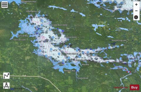
Kabetogama Lake or Lake Kabetogama is a clear lake in northern St. Louis County, Minnesota. This body of water lies within Voyageurs National Park, and with a surface area of 25,760 acres (104 km2), it is one of the state's 10 largest inland lakes. Kabetogama Lake drains into to the east, and roughly parallels the near-by Rainy Lake. The Ojibwe name Gaa-biitoogamaag-zaaga'igan translates to “the lake that lies parallel with another lake” or “the lake that doubles with another lake” or "the place where there is one lake after another." French fur trappers similarly referred to Kabetogama as Travere or Travers, meaning “alongside.” A thin peninsula is all that separates the two lakes. The community of Kabetogama, located along the south shores of the Lake serves as the gateway into the park.
More on Wikipedia...Popular fish species in this lake include Black crappie, Burbot, Lake sturgeon, Lake whitefish, Largemouth bass, Northern pike, Rock bass, Sauger, Silver redhorse, Smallmouth bass, Walleye, White sucker and Yellow perch.
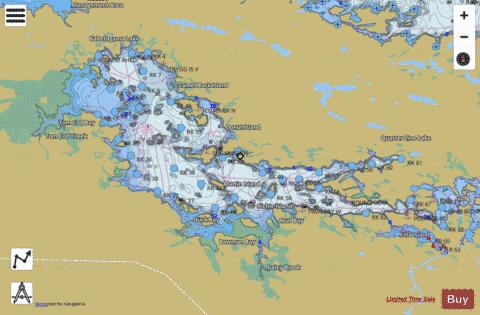
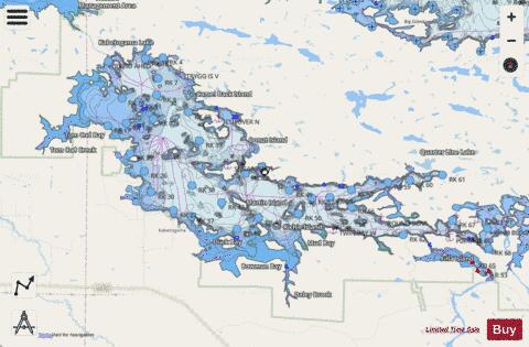
Kabetogama Fishing Map Stats | |
| Title | Kabetogama |
| Scale | 1:24000 |
| Counties | Koochiching, St. Louis |
| Nearby Cities | Island View, Ray, Ericsburg, Ranier, International Falls, Cusson, Nett Lake, Crane Lake, Orr, Buyck |
| Area * | 24050.81 acres |
| Shoreline * | 190.13 miles |
| Min Longitude | -93.13 |
| Min Latitude | 48.40 |
| Max Longitude | -92.78 |
| Max Latitude | 48.53 |
| Edition Label 1 | |
| Edition Label 2 | |
| Edition Label 3 | |
| Id | US_MN_69084500 |
| Country | US |
| Projection | Mercator |
| * some Stats may include nearby/connecting waterbodies | |
|