Lake Murray fishing map is available as part of iBoating : USA Marine & Fishing App(now supported on multiple platforms including Android, iPhone/iPad, MacBook, and Windows(tablet and phone)/PC based chartplotter.).
With our Lake Maps App, you get all the great marine chart app features like fishing spots, along with Lake Murray depth map. The fishing maps app include HD lake depth contours, along with advanced features found in Fish Finder / Gps Chart Plotter systems, turning your device into a Depth Finder. The Lake Murray Navigation App provides advanced features of a Marine Chartplotter including adjusting water level offset and custom depth shading. Fishing spots and depth contours layers are available in most Lake maps. Lake navigation features include advanced instrumentation to gather wind speed direction, water temperature, water depth, and accurate GPS with AIS receivers(using NMEA over TCP/UDP). Autopilot support can be enabled during ‘Goto WayPoint’ and ‘Route Assistance’.
Now i-Boating supports Fishing Points in Lake Murray.
Have more questions about the Nautical Chart App? Ask us.
Fishing Info for Lake Murray
Lake Murray is a reservoir in the U.S. state of South Carolina. It is approximately 50,000 acres (20,000 hectares) in size, and has roughly 650 mi (1,050 kilometres) of shoreline. It was impounded in the late 1920s to provide hydroelectric power to the state of South Carolina. Lake Murray is fed by the Saluda River, which flows from upstate South Carolina near the North Carolina state line. The Saluda Dam (officially the Dreher Shoals Dam) was an engineering feat at the time of its construction. The dam, using the native red clay soil and bedrock, was the largest earthen dam in the world when it was completed in 1930. Lake Murray itself is named after the project's chief engineer, William S. Murray. The Saluda Dam is approximately 1.5 miles (2.4 km) long and 220 feet (67 m) high. Lake Murray is 41 miles (66 km) long, and 14 miles (23 km) wide at its widest point. At the time when the lake was finished, it was the world's largest man-made reservoir. In addition to serving as a source of hydroelectric power for the region, the lake has become a recreational attraction, with fishing and boating being popular activities. Also, Dreher Island State Recreation Area, located in the Western part of the lake, provides multiple activities—all focused on the lake.
More on Wikipedia...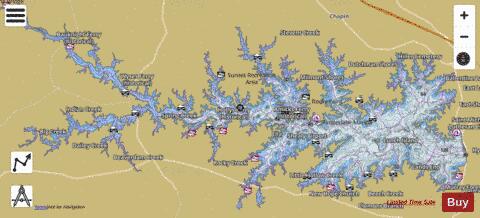
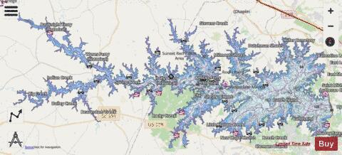
Lake Murray Fishing Map Stats | |
| Title | Lake Murray |
| Sailing Clubs in this Chart region | |
| Columbia Sailing Club | |
| Scale | 1:12000 |
| Counties | Lexington, Newberry, Richland, Saluda |
| Nearby Cities | Ballentine, Chapin, Lexington, Irmo, Little Mountain, Silverstreet, Summit, Richtex, Red Bank, Gilbert |
| Area * | 48760.88 acres |
| Shoreline * | 628.75 miles |
| Min Longitude | -81.69 |
| Min Latitude | 34.00 |
| Max Longitude | -81.22 |
| Max Latitude | 34.17 |
| Edition Label 1 | |
| Edition Label 2 | |
| Edition Label 3 | |
| Id | US_SC_01224900 |
| Country | US |
| Projection | Mercator |
| * some Stats may include nearby/connecting waterbodies | |
|