Anderson Lake fishing map is available as part of iBoating : USA Marine & Fishing App(now supported on multiple platforms including Android, iPhone/iPad, MacBook, and Windows(tablet and phone)/PC based chartplotter.).
With our Lake Maps App, you get all the great marine chart app features like fishing spots, along with Anderson Lake depth map. The fishing maps app include HD lake depth contours, along with advanced features found in Fish Finder / Gps Chart Plotter systems, turning your device into a Depth Finder. The Anderson Lake Navigation App provides advanced features of a Marine Chartplotter including adjusting water level offset and custom depth shading. Fishing spots and depth contours layers are available in most Lake maps. Lake navigation features include advanced instrumentation to gather wind speed direction, water temperature, water depth, and accurate GPS with AIS receivers(using NMEA over TCP/UDP). Autopilot support can be enabled during ‘Goto WayPoint’ and ‘Route Assistance’.
Now i-Boating supports Fishing Points in Anderson Lake.
Have more questions about the Nautical Chart App? Ask us.
Fishing Info for Anderson Lake
Anderson Lake is a 57-acre (23 ha) body of water lying 1.5 miles (2.4 km) west of Chimacum in Jefferson County, Washington. It is located in Section 9, Township 29N, Range 1W. Anderson Lake reaches a depth of 29 feet (8.8 m) at its deepest point and has a water volume of 1,228 acre-feet (1,515,000 m3). The lake drains into Chimacum Creek and Port Townsend Bay. It is surrounded by Anderson Lake State Park. The lake's fish population includes lake-reared rainbow trout, that carry over to a second season from the initial spring fishery. Toxic algae has caused the lake to be closed to all access on multiple occasions. The lake has annual cyanobacteria blooms dominated by dolichospermum (anabaena), aphanizomenon and microcystis. It is a major producer of anatoxin-a, a potent neurotoxin. County health officials have monitored local lakes for blue-green algae seasonally since 2007.
More on Wikipedia...Popular fish species in this lake include Rainbow trout.
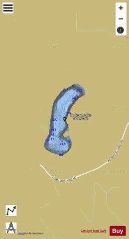
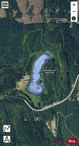
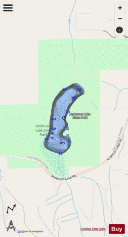
Anderson Lake Fishing Map Stats | |
| Title | Anderson Lake |
| Scale | 1:6000 |
| Counties | Jefferson |
| Nearby Cities | Chimacum, Irondale, Port Hadlock, Port Townsend, Nordland, Beaver Valley, Port Ludlow, Leland, Blyn, Quilcene |
| Area * | 57.31 acres |
| Shoreline * | 1.60 miles |
| Min Longitude | -122.80 |
| Min Latitude | 48.01 |
| Max Longitude | -122.80 |
| Max Latitude | 48.02 |
| Edition Label 1 | |
| Edition Label 2 | |
| Edition Label 3 | |
| Id | US_WA_01515878 |
| Country | US |
| Projection | Mercator |
| * some Stats may include nearby/connecting waterbodies | |
|