Schaalsee Nord fishing map is included in Germany - Schleswig-Holstein Lakes nautical charts folio. It is available as part of iBoating : Inland Europe Marine & Fishing App (now supported on multiple platforms including Android, iPhone/iPad, MacBook, and Windows(tablet and phone)/PC based chartplotter. ).
With our Lake Maps App, you get all the great marine chart app features like fishing spots, along with Schaalsee Nord lake depth map. The fishing maps app include HD lake depth contours, along with advanced features found in Fish Finder / Gps Chart Plotter systems, turning your device into a Depth Finder. The Schaalsee Nord Navigation App provides advanced features of a Marine Chartplotter including adjusting water level offset and custom depth shading. Fishing spots and depth contours layers are available in most Lake maps. Lake navigation features include advanced instrumentation to gather wind speed direction, water temperature, water depth, and accurate GPS with AIS receivers(using NMEA over TCP/UDP). Autopilot support can be enabled during ‘Goto WayPoint’ and ‘Route Assistance’.
Have more questions about the Nautical Chart App? Ask us.
Fishing Info for Schaalsee Nord
Schaalsee is a 24 km2 (9.3 sq mi) lake in Germany. It forms part of the border between Schleswig-Holstein (district Herzogtum Lauenburg) and Mecklenburg-Vorpommern (districts Ludwigslust-Parchim and Nordwestmecklenburg). The town of Zarrentin is located on its southern shores. Other municipalities on the lake are Seedorf, Sterley, Salem, Kittlitz and Kneese. It was declared a biosphere reserve in 2000 (309 km2).
More on Wikipedia...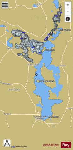
Schaalsee Nord Fishing Map Stats | |
| Title | Schaalsee Nord |
| Scale | 1:24000 |
| Area * | 3860.68 acres |
| Shoreline * | 32.64 miles |
| Min Longitude | 10.87 |
| Min Latitude | 53.55 |
| Max Longitude | 10.96 |
| Max Latitude | 53.64 |
| Edition Label 1 | |
| Edition Label 2 | |
| Edition Label 3 | |
| Id | II_DE_schaalsee___seedorfer_tief_de |
| Country | Inland Europe |
| Projection | Mercator |
| * some Stats may include nearby/connecting waterbodies | |
| |||||||||||||||||||||||||||||||||||||||||||||||||||||||||||||||||||||||||||||||||||||||||||||||||||||||
|