Loch Arthur (Urr Basin) fishing map is included in Scotland - Dumfries and Galloway Lochs nautical charts folio. It is available as part of iBoating : Inland Europe Marine & Fishing App (now supported on multiple platforms including Android, iPhone/iPad, MacBook, and Windows(tablet and phone)/PC based chartplotter. ).
With our Lake Maps App, you get all the great marine chart app features like fishing spots, along with Loch Arthur (Urr Basin) lake depth map. The fishing maps app include HD lake depth contours, along with advanced features found in Fish Finder / Gps Chart Plotter systems, turning your device into a Depth Finder. The Loch Arthur (Urr Basin) Navigation App provides advanced features of a Marine Chartplotter including adjusting water level offset and custom depth shading. Fishing spots and depth contours layers are available in most Lake maps. Lake navigation features include advanced instrumentation to gather wind speed direction, water temperature, water depth, and accurate GPS with AIS receivers(using NMEA over TCP/UDP). Autopilot support can be enabled during ‘Goto WayPoint’ and ‘Route Assistance’.
Have more questions about the Nautical Chart App? Ask us.
Fishing Info for Loch Arthur (Urr Basin)
Loch Arthur (also known as Loch Lotus) is a lake in the council area of Dumfries and Galloway in Scotland near the village of Beeswing. Loch Arthur lies to the east of the village of Beeswing and has been claimed as the setting for the Arthurian story of the Lady of the Lake. Prehistoric lake dwellings (crannogs) were formerly on this lake. A logboat and possible paddle have been found. Loch Arthur Camphill Community is a farm near the loch where people with disabilities, volunteers and staff produce organic cheese, butter and other foods.
More on Wikipedia...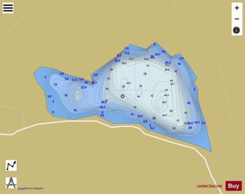
Loch Arthur (Urr Basin) Fishing Map Stats | |
| Title | Loch Arthur (Urr Basin) |
| Scale | 1:6000 |
| Area * | 68.14 acres |
| Shoreline * | 1.63 miles |
| Min Longitude | -3.72 |
| Min Latitude | 55.00 |
| Max Longitude | -3.71 |
| Max Latitude | 55.01 |
| Edition Label 1 | |
| Edition Label 2 | |
| Edition Label 3 | |
| Id | II_SCOT_74400510_1_scot |
| Country | Inland Europe |
| Projection | Mercator |
| * some Stats may include nearby/connecting waterbodies | |
| ||||||||||||||||||||||||||||||||||||||||||||||||||||||||||||||||||||||||||||||||||||||||||||||||||||||||
|