Gooseberry Lake fishing map is included in Saskatchewan Fishing Maps nautical charts folio. It is available as part of iBoating : Canada Marine & Fishing App (now supported on multiple platforms including Android, iPhone/iPad, MacBook, and Windows(tablet and phone)/PC based chartplotter. ).
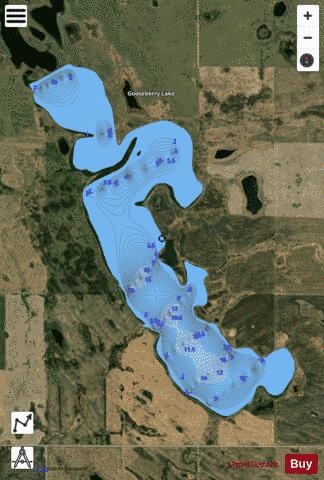
With our Lake Maps App, you get all the great marine chart app features like fishing spots, along with Gooseberry Lake depth map. The fishing maps app include HD lake depth contours, along with advanced features found in Fish Finder / Gps Chart Plotter systems, turning your device into a Depth Finder. The Gooseberry Lake Navigation App provides advanced features of a Marine Chartplotter including adjusting water level offset and custom depth shading. Fishing spots and depth contours layers are available in most Lake maps. Lake navigation features include advanced instrumentation to gather wind speed direction, water temperature, water depth, and accurate GPS with AIS receivers(using NMEA over TCP/UDP). Autopilot support can be enabled during ‘Goto WayPoint’ and ‘Route Assistance’.
Now i-Boating supports Fishing Points in Gooseberry Lake.
Have more questions about the Nautical Chart App? Ask us.
Fishing Info for Gooseberry Lake
Gooseberry Lake is a lake in the Canadian province of Saskatchewan. It is a shallow, natural lake located north-west of Moose Mountain Lake in the Moose Mountain Creek watershed. The lake has a large catchment area and flows into Moose Mountain Lake via the east flowing Gooseberry Creek. It is in the Prairies Ecozone of Palliser's Triangle and the area around the lake has a knob and kettle landscape with poor drainage that, during years with heavy spring run-off or rains, is known to flood. The lake is in the RM of Golden West No. 95 and can be accessed from Highway 711. There are no settlements, facilities, nor amenities on the lake.
More on Wikipedia...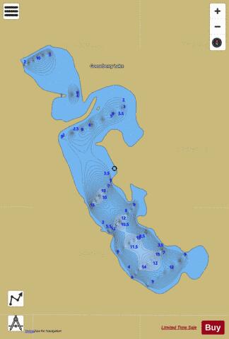
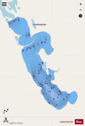
Gooseberry Lake Fishing Map Stats | |
| Title | Gooseberry Lake |
| Scale | 1:12000 |
| Nearby Cities | Weyburn, Indian Head, Estevan, Carlyle |
| Area * | 778.76 acres |
| Shoreline * | 9.67 miles |
| Min Longitude | -103.21 |
| Min Latitude | 49.92 |
| Max Longitude | -103.17 |
| Max Latitude | 49.95 |
| Edition Label 1 | |
| Edition Label 2 | |
| Edition Label 3 | |
| Id | CA_SK_gooseberry_lake__sk |
| Country | CA |
| Projection | Mercator |
| * some Stats may include nearby/connecting waterbodies | |
|