Jumping Lake fishing map is included in Saskatchewan Fishing Maps nautical charts folio. It is available as part of iBoating : Canada Marine & Fishing App (now supported on multiple platforms including Android, iPhone/iPad, MacBook, and Windows(tablet and phone)/PC based chartplotter. ).
With our Lake Maps App, you get all the great marine chart app features like fishing spots, along with Jumping Lake depth map. The fishing maps app include HD lake depth contours, along with advanced features found in Fish Finder / Gps Chart Plotter systems, turning your device into a Depth Finder. The Jumping Lake Navigation App provides advanced features of a Marine Chartplotter including adjusting water level offset and custom depth shading. Fishing spots and depth contours layers are available in most Lake maps. Lake navigation features include advanced instrumentation to gather wind speed direction, water temperature, water depth, and accurate GPS with AIS receivers(using NMEA over TCP/UDP). Autopilot support can be enabled during ‘Goto WayPoint’ and ‘Route Assistance’.
Now i-Boating supports Fishing Points in Jumping Lake.
Have more questions about the Nautical Chart App? Ask us.
Fishing Info for Jumping Lake
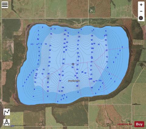
Jumping Lake is a lake a short distance south of Birch Hills, Saskatchewan, Canada. It is a small freshwater lake popular locally for migratory bird hunting, and fishing. In addition to being a stopping point for migrating geese and ducks, the lake is home to a population of walleye which occasionally suffer from . In the mid decades of the twentieth century a beach and recreational facilities existed at the lake frequented by area locals, but these have since been abandoned. The village of was also once found at the eastern edge of the lake which has disappeared for the most part. The countryside surrounding Jumping Lake is typical of the aspen parkland biome of which it is a part.
More on Wikipedia...Popular fish species in this lake include Walleye.
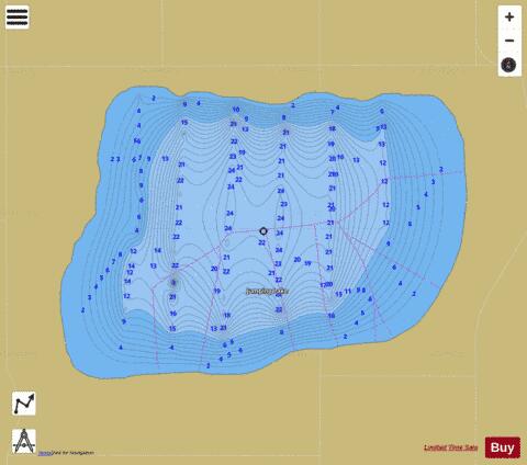
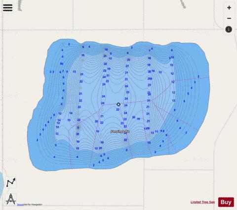
Jumping Lake Fishing Map Stats | |
| Title | Jumping Lake |
| Scale | 1:24000 |
| Nearby Cities | Birch Hills, Prince Albert, Humboldt, Melfort, Rosthern, Shellbrook |
| Area * | 2613.22 acres |
| Shoreline * | 7.97 miles |
| Min Longitude | -105.48 |
| Min Latitude | 52.84 |
| Max Longitude | -105.42 |
| Max Latitude | 52.87 |
| Edition Label 1 | |
| Edition Label 2 | |
| Edition Label 3 | |
| Id | CA_SK_Jumping_Lake_sk |
| Country | CA |
| Projection | Mercator |
| * some Stats may include nearby/connecting waterbodies | |
|